Polar Vortex Sends Arctic Air South as Winter Storm Threatens the South and East (USA)
") |
| Frigid temps expected to blast much of US |
A deep push of Arctic air is spreading out of Canada and tightening its grip on a large part of the United States, setting up a high-impact stretch of winter weather.
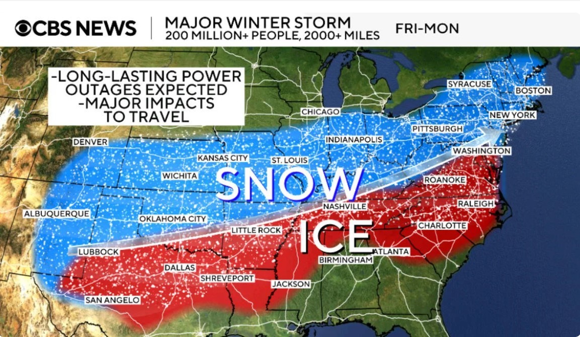
Forecasters expect widespread subfreezing temperatures, dangerous wind chills, and a major storm capable of producing snow, sleet, and damaging ice from the Southern Plains into the Southeast and Mid-Atlantic.
If you remember just one thing, make it this: cold air arrives first, then the storm rides along its southern edge. That’s the classic setup for ice and sleet in the South and heavy snow farther north.
The big picture: two threats at once
-
Extreme cold across the northern tier and interior East, with wind chills well below what thermometers show.
-
A late-week to weekend winter storm spreading from Texas/Oklahoma toward the Carolinas and beyond, with the greatest risk of dangerous icing where temperatures hover near freezing.
Read more: Coldest Night of the Season: Rain, Snow Mix and Dangerous Cold Hit New York
Timing: When the Worst Weather Hits
Forecast details will shift, but the overall timeline is becoming clearer:
-
Friday into Friday night (Jan 23–24): Wintry precipitation expands across parts of Oklahoma, north and west Texas, Arkansas, and into the Mid-South, then spreads east into the Tennessee Valley and Appalachians.
-
Saturday (Jan 24): Snow and ice push farther east and south, with mixed precipitation possible across portions of the Deep South while heavier snow develops into parts of the Appalachians and interior East.
-
Sunday (Jan 25): Wintry weather continues into the Carolinas, Mid-Atlantic, and parts of the Northeast, with lingering impacts possible if cold air remains locked in behind the storm.
AP reports the storm could become a “potentially catastrophic” ice event in parts of the South if heavier freezing rain bands set up over the same areas.
Region-by-Region Forecast: What to Watch
Midwest and Great Lakes: deep freeze + lake-effect snow
The cold is already intense across parts of the northern Plains, Upper Midwest, and Great Lakes. Strong winds can push “feels-like” temperatures dangerously low, while lake-effect snow targets favored belts downwind of the Great Lakes.
South (Texas to Georgia): the ice danger zone
In the South, the most disruptive impacts often come from freezing rain, not snow. Ice can make roads impassable and adds weight to trees and power lines, increasing the chance of outages. Forecasts highlight a broad corridor where significant icing is possible from parts of Texas toward the Southeast.
Appalachians, Mid-Atlantic, Northeast: snow and slick travel
As the storm shifts east, colder air on the north side favors snow across higher elevations and inland locations. Major population corridors can see rapid changes from rain to sleet to snow depending on the storm track.
Why This Is Happening: A Quick Polar Vortex Explainer
The polar vortex is a large circulation of very cold air in the upper atmosphere around the Arctic. When the jet stream becomes wavier, parts of that cold can surge south, delivering unusually cold outbreaks to the U.S.
This week’s pattern fits that playbook: Arctic air presses south, then storm systems tap Gulf moisture and run into that cold dome—fuel for widespread snow and ice.
Safety and Preparedness: The “3 P’s” Rule
People, Pets, Pipes. Handle these first, then worry about everything else.
Wind chill and frostbite risk
Wind chill is calculated using wind speed and air temperature to estimate how quickly exposed skin loses heat. The National Weather Service notes the index uses wind speeds adjusted to about 5 feet above the ground and modern heat-transfer theory.
Do this:
-
Dress in layers; cover hands, ears, and face.
-
Limit time outdoors when wind chills drop near or below zero.
-
Check on older neighbors and anyone without reliable heat.
Before ice and snow arrive
-
Charge phones, power banks, and medical devices.
-
Stock water, simple food, and batteries for 48–72 hours.
-
Avoid travel during freezing rain; bridges and overpasses ice first.
-
Drip faucets and insulate exposed pipes where freezing is likely.
Cold snaps can persist even in a warming Arctic
Research summarized by NOAA and climate groups notes that cold-air outbreaks can continue for decades even as the Arctic warms rapidly, because atmospheric patterns that steer cold air may still produce major southward intrusions.
Bottom line
Expect dangerous cold across a broad swath of the country and a high-impact winter storm late week into the weekend, especially from Texas to the Carolinas. Track local watches and warnings closely, because small shifts in storm track can mean the difference between rain, heavy snow, or damaging ice.