Weather Alert: Freezing Rain Threat in New York as Wintry System Lingers Through Monday

 |
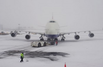
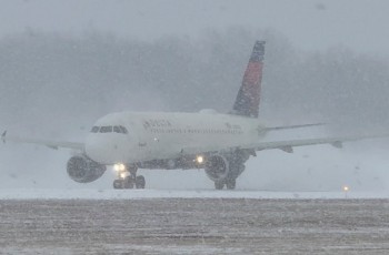
| A winter storm cancelled over 1,800 US flights. Here’s why New York’s airports suffer the most and how snow in NYC ripples across the entire air travel network. |
New Yorkers are facing a fresh weather threat after a powerful late-December storm left snow on the ground across much of the state: a freezing rain advisory is in effect for parts of the region through Sunday evening, with slick travel and hazardous conditions expected to continue into Monday, December 29, 2025 as temperatures struggle to rebound.
The National Weather Service and local forecast offices have highlighted the risk of freezing rain and icy glaze forming on roads and sidewalks starting Sunday evening, especially north and west of New York City in the Hudson Valley and interior regions. This comes on the heels of one of the most notable post-Christmas snow events the metropolitan area has seen in years, with snow totals above average for much of the Tri-State area. In Central Park, New York City recorded more than four inches of snow, the most for a December storm since early 2022.
Higher snowfall was reported in northern suburbs and parts of Connecticut. Snowfall totals ranged widely, with some Hudson Valley and Long Island communities recording over six inches. State officials had declared a state of emergency to mobilize resources and prepare for treacherous conditions earlier in the holiday weekend.
Read more: Major Winter Storm Brings Snow, Ice, and Blizzard Conditions to 40 Million Americans
Freezing Rain Advisory and Ice Risks Sunday Evening
A Winter Weather Advisory for freezing rain is in place from late Sunday afternoon through Sunday night for interior counties including Sullivan, Ulster, Dutchess, Orange, Rockland, Putnam, and parts of northern New Jersey and Connecticut. Meteorologists warn that temperatures hovering near or below freezing at the surface, combined with a warm layer above the ground, will create a classic setup for freezing rain — precipitation that falls as liquid but freezes on contact with cold surfaces. Even a thin glaze of ice can make roads, bridges, and walkways extremely dangerous.
Forecast models show that while daytime Sunday may be mostly dry with sunshine in some areas, clouds will thicken by late afternoon and precipitation will begin moving in by early evening. Surface temperatures are expected to remain cold enough for freezing rain to reach the ground, especially in the higher terrain of the Hudson Valley and Catskills before changing over to plain rain closer to New York City as surface temperatures rise slightly later Sunday night.
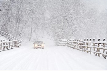
Travel Hazards and Preparedness
Authorities are urging caution for Sunday evening and overnight travel. Police and transportation departments say even a light ice coating — as little as a tenth of an inch — can lead to slippery roadways, bridges icing over, and slower response times for emergency vehicles. Residents are encouraged to allow extra time for commutes, reduce vehicle speeds, and be alert for untreated back roads and shaded areas that freeze first. Local school and municipal officials are already planning salting and plowing operations where necessary.
Forecast for Monday, December 29
Looking ahead to Monday, the precipitation is expected to switch over to rain for much of the region, particularly in the lower Hudson Valley and New York City area, as a brief warm-up arrives. Temperatures may climb into the upper 30s to 40s in eastern parts of the state, with rain possible through the afternoon. While this transition will reduce the immediate freezing rain threat, standing ice from Sunday night’s event may linger into Monday morning, keeping roads and sidewalks slick until the warmer air fully stabilizes the surface. In higher elevations and farther north, a mix of rain and snow cannot be ruled out, with light snow showers Monday night before colder air returns.
Public Safety and Infrastructure Readiness
State and local officials emphasize readiness. Snow removal crews are active, spreading salt and sanding high-risk roadways, while transit agencies are monitoring conditions closely to keep buses and commuter rail services running safely. Officials are also encouraging residents to check on vulnerable neighbors, especially older adults, and take precautions to avoid falls on icy walkways.
Bottom Line
While New York shakes off the bulk of the recent snowstorm, the threat of freezing rain on Sunday evening and icy conditions into Monday remains a serious concern. Even if accumulations are light, the impact on travel and public safety can be significant as residents return home from holiday travels and prepare for the week ahead.