Major Winter Storm Brings Snow, Ice, and Blizzard Conditions to 40 Million Americans
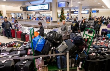 What Travelers Can Still Do When Winter Storms Cancel Hundreds of Flights What Travelers Can Still Do When Winter Storms Cancel Hundreds of Flights |
 Holiday Travel Chaos: Powerful Winter Storm Cancels and Delays Thousands of U.S. Flights Holiday Travel Chaos: Powerful Winter Storm Cancels and Delays Thousands of U.S. Flights |
Winter Storm Warning: Current Situation
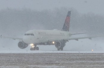
The storm system is moving eastward from the Dakotas through the Midwest and Great Lakes. Blizzard and Winter Storm Warnings are in effect across parts of Minnesota, Michigan’s Upper Peninsula, and Wisconsin, with snowfall and wind gusts creating whiteout conditions and near-zero visibility.
In the Northeast, Winter Weather Advisories cover areas from Pennsylvania through Vermont and Maine, where freezing rain and ice are concerns as the system progresses. Flood watches have also been issued near Buffalo and Jamestown, New York due to possible rainfall followed by snow.
High wind alerts extend to cities like Detroit and Cleveland, where gusts up to 60 mph on Sunday night into early Tuesday morning could worsen conditions.
Read more: What Travelers Can Still Do When Winter Storms Cancel Hundreds of Flights
 |
| US Winter Weather Warnings |
City-by-City Forecast
Minneapolis
Sunday (Dec. 28):
-
Heavy snow develops and intensifies
-
Winds increase, gusting over 35–45 mph
-
Visibility drops significantly due to blowing snow
Monday (Dec. 29):
-
Snow tapers off early
-
Bitter cold and lingering blowing snow continue
-
Travel remains extremely dangerous in rural and open areas
Official alert: Blizzard Warning / Winter Storm Warning
Primary risk: Whiteout conditions and stranded vehicles
Chicago
Sunday:
-
Periods of rain during the day
-
Temperatures begin falling late afternoon and evening
Sunday night into Monday:
-
Rain transitions to snow
-
Strong winds create slick and hazardous driving conditions
-
Untreated roads and bridges likely freeze
Official alert: Winter Storm Warning
Primary risk: Black ice and wind-driven snow during commute hours
Read more: Weather Alert: Freezing Rain Threat in New York as Wintry System Lingers Through Monday
Detroit
Sunday:
-
Rain and mixed precipitation
-
Winds strengthen through the day
Monday:
-
Snow showers continue
-
Gusty winds reduce visibility
-
Very cold air moves in by evening
Official alert: Winter Storm Warning / Winter Weather Advisory
Primary risk: Slippery roads and sudden visibility drops
Why This Storm Is DangerousA large and dynamic winter storm is impacting the Midwest, Great Lakes, and Northeast, bringing a complex mix of rain, snow, freezing rain, strong winds, and rapidly falling temperatures. Meteorologists warn this system is especially hazardous because: Rain is quickly changing to snow or ice Temperatures are dropping sharply behind the storm Strong winds are producing blowing and drifting snow Wet roads may flash-freeze within minutes |
Cleveland
Sunday night:
-
Rain changes to snow as temperatures fall
-
Strong winds begin behind the cold front
Monday:
-
Snow showers and blowing snow
-
Roads turn icy quickly, especially overnight and early morning
Official alert: Winter Storm Warning
Primary risk: Flash freezing and poor road conditions
Buffalo
Sunday:
-
Mixed precipitation early
-
Winds increase across western New York
Monday:
-
Lake-effect snow intensifies
-
Heavy snow bands possible with rapid accumulation
-
Blowing snow significantly reduces visibility
Official alert: Winter Storm Warning / Lake-Effect Snow Warning
Primary risk: Heavy snow, whiteouts, and localized travel shutdowns
New York City
 |
| US Winter weather forecast |
Sunday:
-
Storm exits, leaving wet roads and sidewalks
-
Temperatures begin to fall after sunset
Monday:
-
Dry but colder
-
Overnight refreeze leads to icy patches on bridges and sidewalks
Official alert: Winter Weather Advisory
Primary risk: Black ice during late night and early morning hours
Boston
Sunday evening:
-
Freezing rain and wintry mix possible
-
Even light ice accumulation creates dangerous conditions
Monday:
-
Gradual improvement, but lingering slick surfaces
-
Cold air remains in place
Official alert: Ice Storm Warning / Winter Weather Advisory
Primary risk: Ice-coated roads, sidewalks, and potential power issues
Regional Trend Summary
Midwest & Upper Midwest
-
Blizzard conditions
-
Heavy snow with strong winds
-
Travel may be impossible at times
Great Lakes
-
Rain to snow transition
-
Strong winds and blowing snow
-
Flash freezing overnight
Northeast
-
Icy conditions and freezing rain in New England
-
Black ice risk in major metro areas
-
Colder, drier air settles in by Monday night
Official Safety Guidance
-
Avoid travel during Winter Storm or Blizzard Warnings
-
Slow down and increase following distance
-
Bridges and overpasses freeze first
-
Keep emergency supplies in your vehicle
-
Monitor updates from local National Weather Service offices
Bottom Line
From Minneapolis to Buffalo, this winter storm brings high-impact snow and wind, while cities like Boston and New York face dangerous ice and refreeze conditions. Conditions may change quickly, and officials urge the public to take warnings seriously and limit travel through Monday.