Top 20 Weirdest Borders on the Planet For Discovering
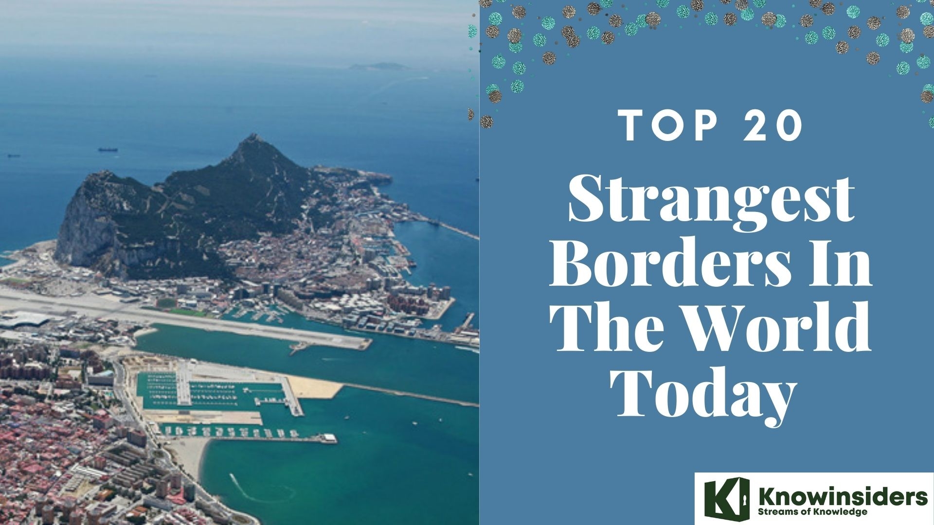 |
| Top 20 strangest borders in the world |
| Table of Content |
We like to think that countries are separated by their borders. The flags, checkpoints, and guards set up by humans serve to clearly demarcate the entry and exit points. While some argue that borders actually foster diversity, others argue that it merely reflects existing divisions.
The potential for union at the border gives me hope. The border is the meeting place of two nations, two cultures, and countless individuals. "Hope springs eternal where there is unity." For the uninitiated, Nimrod Danishman, the Israeli playwright and theatre personality quite aptly sums up how borders are an inevitable part of the global landscape.
Here are some of the most out-there and bizarre international boundaries from around the globe.
What Are Borders?
An area's border is the line dividing it. Boundaries may be artificial or genuine. Territories delineate nations, states, counties, provinces, cities, and towns. An area under government control is delineated by a border. Only inside its boundaries can a region's government enact and enforce laws.
Boundaries alter. A region can occasionally become dominated by its inhabitants. Land can occasionally be peacefully exchanged or sold. After a war, governments frequently divide up the land.
Travel Between Countries
Occasionally, borders coincide with geographical features such as mountain ranges or rivers. For instance, the Pyrenees mountain range forms the border between France and Spain. The Rio Grande River serves as the border between the United States and Mexico for a portion of its length.
Travel is impacted by borders, particularly national borders. People traveling from one nation to another are also impacted by borders.
Similar economic and political systems tend to make nations more hospitable to one another. These nations frequently maintain open borders without having military personnel stationed there to provide security.
There are vastly different laws in other parts of the world. The border separating North and South Korea is known as the Korean Demilitarized Zone. With soldiers, explosives, and fences, it divides the two nations. Passports and authorization are required for foreign nationals to enter North Korea. Before leaving the nation, North Koreans must obtain permission from the authorities, though.
Every nation has its own laws governing borders. These regulations determine who is allowed to enter, depart from, and reside within a nation.
Work permits and visas are issued by the government. Noncitizens are the recipients of them. The kinds of work and the duration of their travels within the nation are restricted by work permits and visas. "Green cards," or cards designating permanent residency, are issued by the US. Foreign nationals with green cards are entitled to live, work, and enjoy legal protections within the boundaries of the United States.
Border Protection
Nations guard their borders for a variety of reasons. This is particularly true in regions where multiple nations have engaged in conflicts over shared territory. Thailand and Cambodia are nations in Southeast Asia. For over a century, they have been at odds over the Preah Vihear Temple's territory.
Borders can occasionally prevent people from leaving their nation. People living in countries like Cuba, North Korea, and Myanmar are rarely permitted to leave their borders.
Border Disputes
Conflicts over natural resources are the root cause of many border disputes. Anything that can be used by humans and originates from the natural world is considered a natural resource. Sudan and Egypt have been at odds over the Hala'ib region for many years. Manganese is a naturally occurring mineral that is abundant in Hala'ib. Steel and iron production require manganese.
Boundaries frequently separate groups of people who lead comparable lifestyles. It's possible that both groups follow the same religion. They may even speak the same language and adhere to the same customs.
Following Germany's defeat in World War II, the country was split into East and West Germany. The countries' border was in place from 1949 until 1989. In 1990, Germany reunited as a single nation.
One ethnic group often aspires to secede and establish its own sovereign nation. The result could be a civil war.
There is a long history of border conflicts in the Balkan region of southeast Europe.
Yugoslavia became a communist nation following World War II. People cannot own property under communism because all property is deemed to be shared. Generally speaking, the government distributes wealth equitably or in accordance with what people require. However, this is not always a very effective solution.
Conflicts over power erupted in the Balkans as a result of the fall of communism in the early 1990s. Yugoslavia was home to numerous ethnic groups. A number of factions fought for independence. The region that was once Yugoslavia is now divided into seven different countries as a result.
When people from different regions seize control of an area and draw borders, border issues frequently arise. A large portion of Africa was colonized by European nations in the 1800s and 1900s. Stated differently, immigrants from Europe settled in Africa. They seized power over the local populace. They seized ownership of the territory. The borders of most African countries were drawn by European colonists. But frequently, they drew borders without taking into account the various communities that called a region home.
Most African countries had been freed from European colonial rule by the late 1960s. The Hutu and Tutsi tribes in Central Africa started fighting after Belgian troops left. Two new nations were formed in 1962. It was Hutus who led Rwanda. Tutsi was in charge of Burundi. Thousands of people died in Rwanda in 1994 as a result of a genocide.
The goal of African leaders today is to establish borders that are secure and tranquil. The people of southern Sudan cast ballots to become their own nation in January 2011. The vote was accepted by Sudan's president.
Conflicts over borders can also arise when groups of people want to found their own cities. We refer to this procedure as incorporation. Many suburban or rural dwellers are against incorporation. Rather than being a part of a town or city, they would rather remain an unincorporated area within a county. They claim it will result in additional regulations and taxes.
Other locals are in favor of incorporation. They claim that becoming a town or city will grant them greater autonomy over matters such as education and law enforcement.
What are the Weirdest Borders in the World?
1. Jungholz, Austria/Germany
 |
| Photo: Barry's Borderpoints |
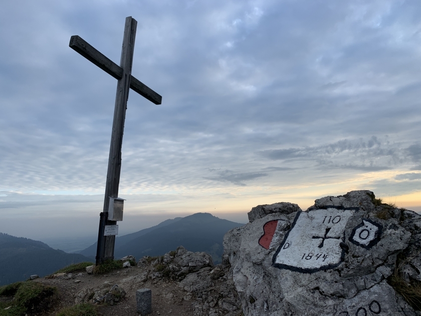
The only route to Jungholz, a village in the Reutte district of the Austrian state of Tyrol, is through Germany. Until Austria joined the EU in 1995, Jungholz was part of the German customs area due to the lack of a road connection to any other part of the country. Additionally, until 2002, when the euro replaced the Austrian schilling as currency, it used the Deutsche Mark. You can use an Austrian or German postal code when writing to Jungholz.
Imagine how much easier it would be to go from one place in your country to another by using the roads of another! You can either drive through Austria on the road to Jungholz or you can hike up the mountain!
 |
| Photo: am proehl |
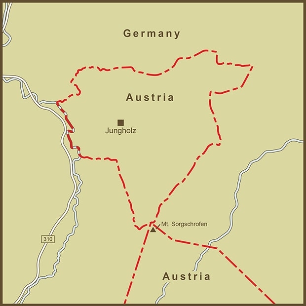
Jungholz is a pene-exclave of Austria, separated from the main part of the country only by the summit of Sorgschrofen (1,636 m, 5,367 ft). In addition to border post 110 on the main international border between Tyrol and Bavaria, there is also a second border that begins and ends in Jungholz after going around it. As a result, a quadripoint is a point with borders that extend in four directions from the summit. At that point, two municipalities from Austria—Reutte, Tyrolean—and Germany—Bavarian, Oberallgäu—come together, with Jungholz leading the way clockwise:
Jungholz (Austrian, north)
Pfronten (German, east)
Schattwald (Austrian, south)
Bad Hindelang (German, west)
2. India – Pakistan Border From Space
 |
| Photo: NASA |
The international boundary dividing India and Pakistan is called the International Border (IB) in the local language. Its southern boundary is Sir Creek, a tidal estuary in the Rann of Kutch that separates the Pakistani province of Sindh from the Indian state of Gujarat. Its northern boundary is the Line of Control, which divides India from Pakistani-administered Kashmir.
The international boundary dividing India and Pakistan is called the International Border (IB) in the local language. Its southern boundary is Sir Creek, a tidal estuary in the Rann of Kutch that separates the Pakistani province of Sindh from the Indian state of Gujarat. Its northern boundary is the Line of Control, which divides India from Pakistani-administered Kashmir.
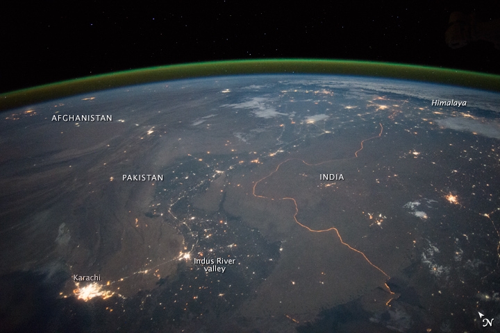
This image was taken at night by an astronaut on board the International Space Station as they looked north across the Indus River valley in Pakistan. The bright hive of lights facing the otherwise pitch-black Arabian Sea is the port city of Karachi. The great curves of the Indus valley are closely followed by the dark color of dense agriculture and the lights of the cities. For comparison, it is 1,160 kilometers (720 miles) from Karachi to the foothills of the Himalayas.
One of the few locations on Earth where an international border is visible at night is depicted in this photo. Security lights with a distinctly orange tone illuminate the serpentine border between Pakistan and India. The border region is seen in another nighttime photo, facing southeast from the Himalaya. During the day, the verdant curves of the Indus Valley can be seen snaking through the arid landscape.
3. Diomede islands, Russia/America Border
 |
| Photo: AS USA |
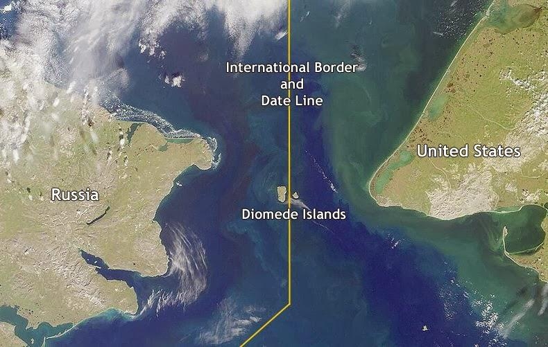
Swim the 3.8km between the rocky islands of Big Diomede and Little Diomede in the Bering Strait, which connects Siberia and Alaska.
But if you did, you'd be transported either back in time or into the future, depending on which way you went.
The Diomedes are located on either side of the international date line, which means that despite being only a few miles apart, Big Diomede (administered by Russia) is a full 21 hours ahead of Little Diomede (administered by the United States).
They've earned the nicknames Tomorrow Island (Big Diomede) and Yesterday Isle (Little Diomede).
The Diomede Islands, also known as the Gvozdev Islands in Russia (Russian: островá водева, ostrová Gvozdjeva), are made up of two rocky, mesa-like islands.:
Big Diomede, a Russian island (part of Chukotka Autonomous Okrug), is also known as Imaqiq, Inaliq, Nunarbuk, or Ratmanov Island.
Little Diomede (part of Alaska) or Ialiq, also known as Krusenstern Island in the United States.
The Diomede Islands are located in the Bering Strait, which connects mainland Alaska and Siberia. The Chukchi Sea is to the north, and the Bering Sea is to the south. Fairway Rock, 9.3 kilometers (5.8 miles) to the southeast, is also Alaskan, but it is not considered to be a part of the Diomede Islands. Big Diomede is nearly a day ahead of Little Diomede due to the International Date Line, but not entirely; due to locally defined time zones, Big Diomede is only 21 hours ahead of Little Diomede (20 in summer). As a result, the islands are also known as Tomorrow Island (Big Diomede) and Yesterday Island (Little Diomede).
4. Norway – Sweden Border
 |
| Photo: The Conversation |
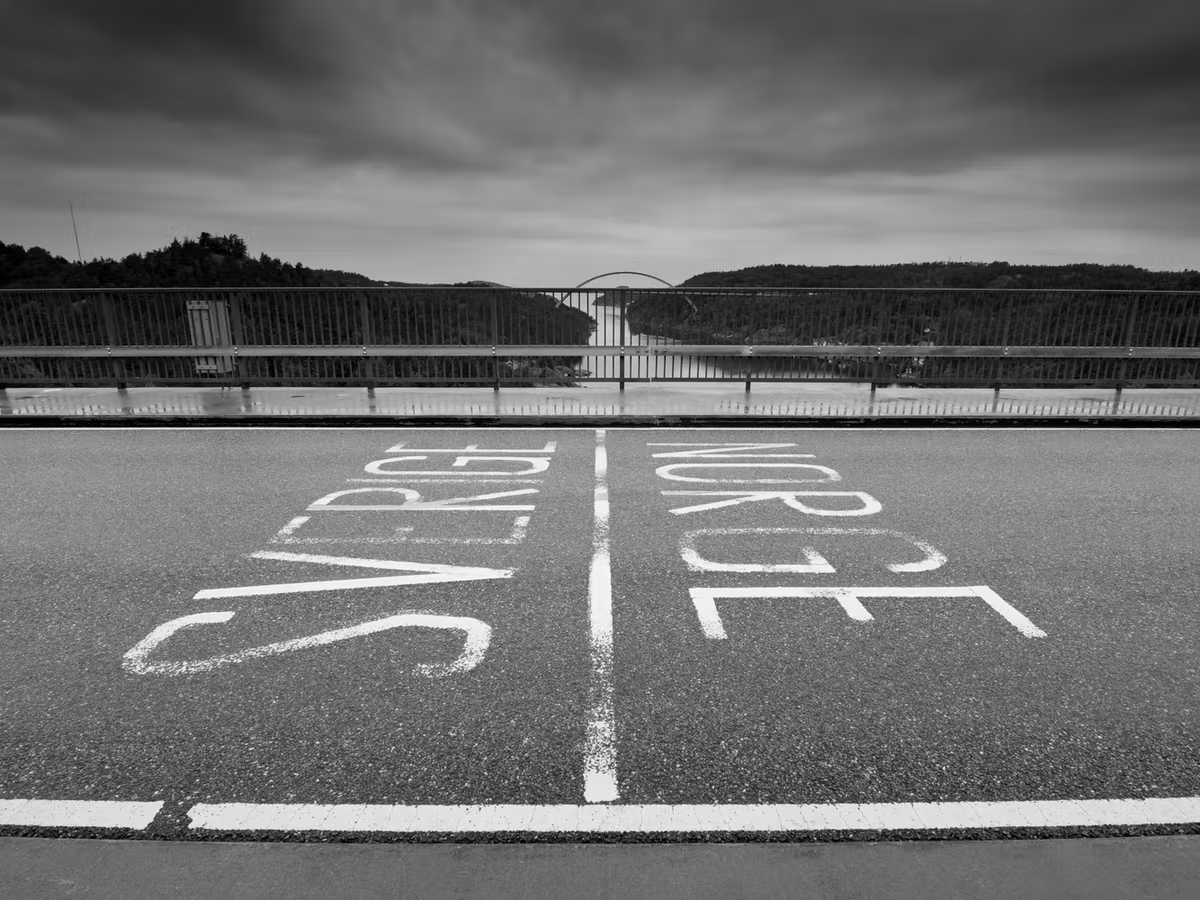
The border between Sweden and Norway is 1630 kilometers long and mostly follows the demarcation of waters in the Scandinavian Alps. It begins in the north at the "Treriksroset" tripoint on the banks of Lake Goldajarvi, where a monument marks the crossing of the Swedish and Norwegian borders. The border ends in the south near the village of Sponvika in the municipality of Halden.
The border has changed several times, most notably as a result of armed conflicts. Under the terms of the Treaty of Bromsebro, the kingdom of Denmark-Norway ceded several provinces to Sweden in 1645, later ceding Trondelag and Bohuslan to Sweden in 1658. The Treaty of Copenhagen, signed in 1660, confirmed the terms of the preceding treaties but required Sweden to return Trondelag.
Following the dissolution of the union between Norway and Sweden in 1905, Norway was forced to demolish several of its border fortresses.
During WWII, many Norwegians fled their country, which was then occupied by Germany, to settle in Sweden, a neutral country.
This is a well-established border that has seen few changes since the two states were formed.
4. Two countries, once couch- Netherlands/Belgium
 |
| Photo: Wikipedia |
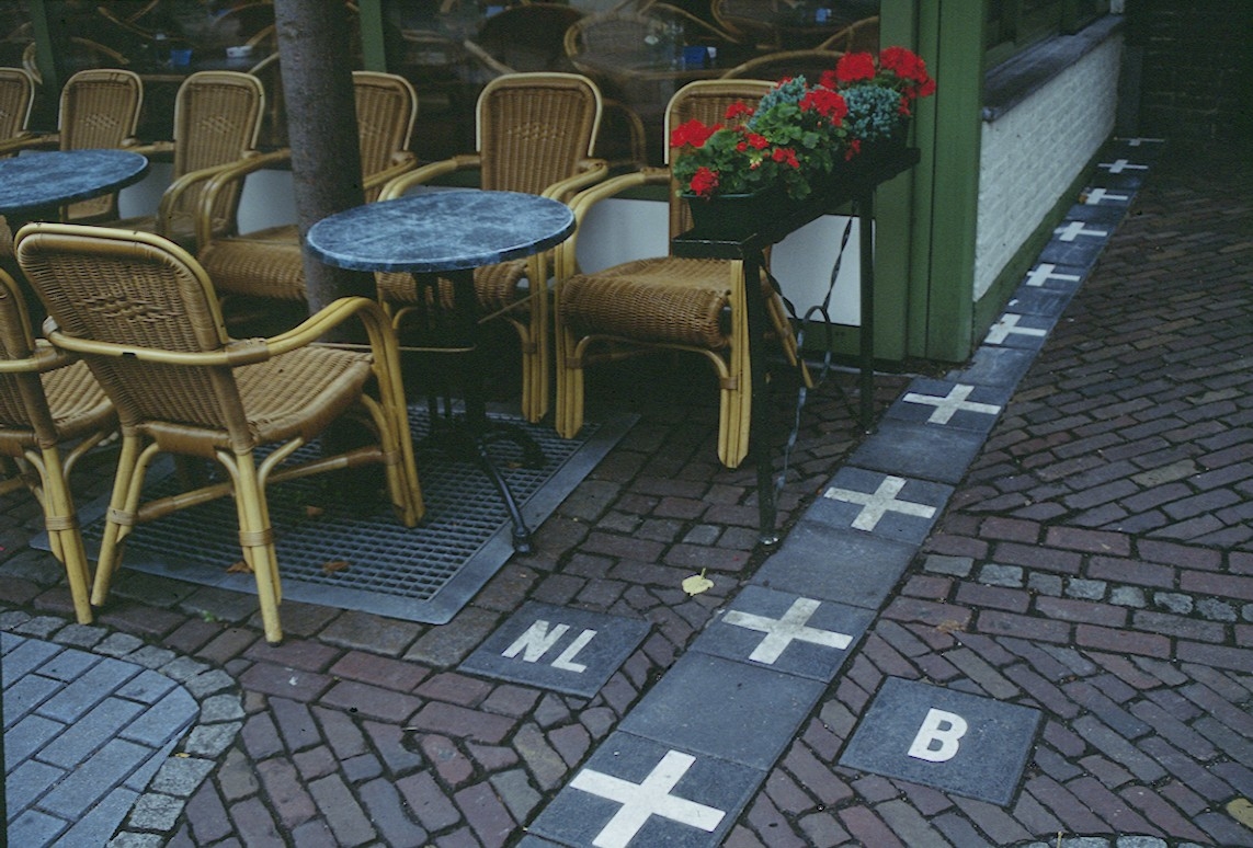
It takes some time to grasp the mind-boggling complexities of the Netherlands/Belgium border located in the municipalities of Barrle-Nassau and Barrle-Hertog.
There are 22 Belgian exclaves (legally part of Belgium but completely surrounded by Dutch land) on the Dutch side of the border, and three other pieces of Belgian land that span the border between the two countries.
But if only it were that easy.
There are also six Dutch exclaves within Belgium's largest exclave and one within the second-largest exclave. If you will, exclaves within exclaves.
Because the borders are so intricate, many homes and businesses are split down the middle between the two countries. Because the rooms are on either side of the border, residents wake up in one country and eat breakfast in another.
Belgium and the Netherlands are separated by a 450-kilometer (280-mile) border.
The Schengen Area includes Belgium and the Netherlands. This means that no permanent border controls exist at this point.
The border is shared by four Flemish provinces (four of the five in the Flemish Region) on the Belgian side. West Flanders, East Flanders, Antwerp, and Limburg (Belgium), from west to east. The Walloon province of Liège, which includes the German-speaking East Cantons, shares a small portion. The border is shared by three provinces in the Netherlands: Zeeland, North Brabant, and Limburg.
The Meuse (Maas) river forms the majority of the border between Belgian and Dutch Limburg. The remainder of the border is mostly on land. In the Netherlands, the city of Baarle-Hertog forms a Belgian exclave. There is a complicated border there, with Dutch exiles inside.
The tripoint (along with Germany) at Vaalserberg marks the eastern end point.
5. No Man’s Land Bir Tawil- Egypt/Sudan border
 |
| Photo: Wikimedia Commons |
Sudan's border relations with Egypt have been marked by mutual suspicion rather than peaceful exchange since the country's independence in 1956. This legacy has been exacerbated over the decades by a slew of obstacles and conflicts, particularly over the disputed Halayeb triangle, even though both sides attempted to improve relations following Egypt's 2011 uprising. Border communities have pushed for stronger ties as a result of this reality, but mistrust has prevailed to the detriment of both countries.
Egypt and Sudan share a 1,276-kilometer border, making it Egypt's longest land border. The border is also the most populous in Egypt, with 2.2 million people living in the three southern governorates of Aswan, New Valley, and Red Sea.10 Geographically, the border can be divided into three sections. The disputed Halayeb triangle, which is rich in minerals and gold, is located in its easternmost section, which begins on the Red Sea. Due to high levels of aridity in some areas, increased security measures, and a famine legacy, living conditions in this region are difficult. Nomadic tribes such as the Ababda and the Basharya predominate in the region.
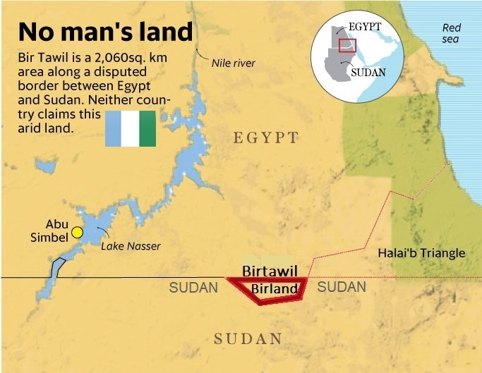
We've all heard of disputed territories, which are claimed by two opposing states for historical, cultural, or geopolitical reasons.
But what about territory that nation states actively avoid?
Surprisingly, this also exists, as evidenced by the bizarre standoff between Egypt and Sudan.
Bir Tawil, a 2,000-square-kilometer-large roadless desert patch, is uninhabited and unwanted because both countries prefer their own historical boundary lines. Bir Tawil remains unclaimed because accepting it would weaken their respective claims to it.
Indeed, because of Bir Tawil's unique status (being both habitable and rejected by its neighboring states), multiple organizations - and even individuals - have attempted to claim the land for themselves, with little support from the international community.
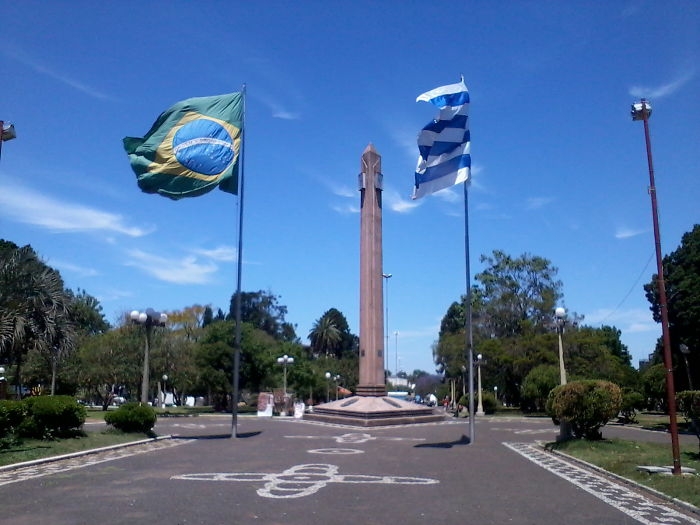
6. Brazil - Uruguay Border, Two Sister Cities Known As The "border Of Piece" (Rivera And Santana)
 |
| Photo: Wikipedia |
The Brazil-Uruguay border is a strip of land located south of Rio Grande do Sul, Brazil's southernmost state. It stretches 985 kilometers west from the triple border of Brazil, Argentina, and Uruguay to the mouth of Arroyo Chu, Brazil's southernmost point.
The western border is defined by the Quara River, a tributary of the Uruguay River, and the "coxilhas of Santana." The Jaguaro River, which flows into the Lagoa Mirim, forms its eastern border. The border then runs from the lagoon's southern end to the Chui.
The Brazilian Island and the Corner of Artigas (interfluve between the Quara River and the Arroyo Invernada) are two disputed areas on the border between Brazil and Uruguay. The two areas are administered by Brazil but have been claimed by Uruguay for decades.
7. Penon de Velez de la Gomera, Morocco/Spain border
 |
| Photo: Reddit |
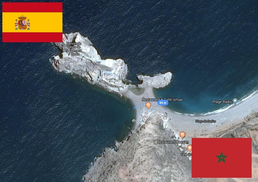
Peón de Vélez de la Gomera is a disputed Spanish exclave and rocky linked island in the western Mediterranean Sea that Morocco claims. A sandy isthmus connects the islet to the Moroccan coast. A rocky isthmus connects it to La Isleta, a smaller islet to the east. The linked island was named Hajar Badis (Badis Rock) and was linked to the town of Badis.
Vélez de la Gomera is a premodern overseas possession known as a plaza de soberana, along with La Isleta. It is administered by the Spanish central government and is home to a small number of Spanish military personnel.
Its border with Morocco is only 80 meters (264 feet) long, making it the world's shortest international border.
In 1496, Portugal and Spain signed an agreement that effectively established their zones of influence on the North African coast. As a result, Spain could occupy only the territory east of Peón de Vélez. This restriction was lifted following the 1578 Battle of Alcácer Quibir by the Iberian Union of Portugal and Spain, when Spain began to take direct actions in Morocco, such as the occupation of Larache.
In 1508, Spain led a successful expedition led by Pedro Navarro to capture the Peón, which was held by pirates who were constantly attacking and looting the coast of Southern Spain.
In 1522, Spain lost the Peón to a Moroccan Berber attack, which killed the entire Spanish garrison. In 1554, Ali Abu Hassun, the new Wattasid ruler of Morocco, gave the Peón to Ottoman troops who had helped him gain the throne.
The Ottomans used it as a base for corsairs operating in the Strait of Gibraltar region. The Saadid sultan Abdallah al-Ghalib was alarmed by this activity, fearing that the Ottomans would use Badis as a base for their conquest of Morocco. He forced the Moroccans to flee the town and the Peón, which he handed over to the Spaniards in 1564. The Moroccan population relocated to Senada's kasbah.
The territory was attacked in 2012 by a group of Moroccan activists from the Committee for the Liberation of Ceuta and Melilla, led by Yahya Yahya.
8. Gibraltar, UK/Spain
 |
| Photo: El Pais in English |
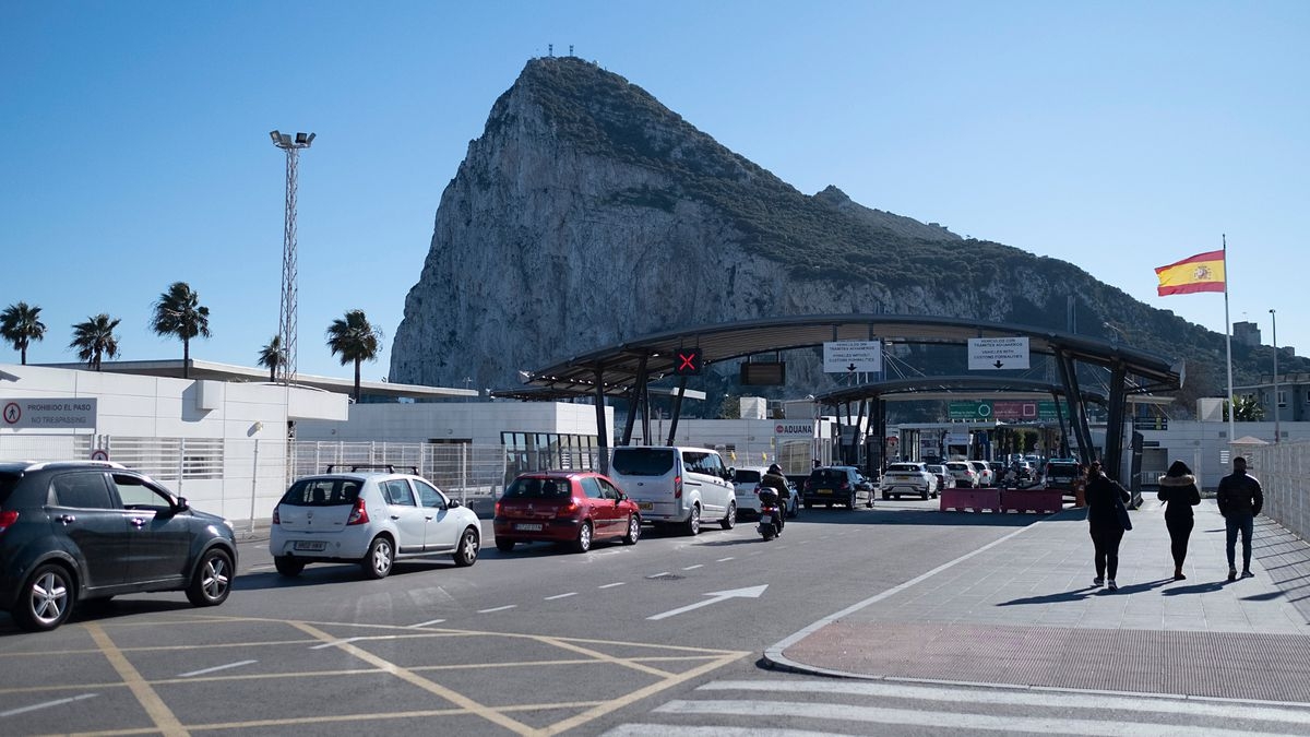
Gibraltar is a British territory that shares only one land border with Spain. If you're looking for a sunny vacation in the UK, this small town has a fascinating history and a few amazing beaches to enjoy!
Gibraltar is a British Overseas Territory on the Iberian Peninsula's southern tip. It is 6.7 km2 (2.6 sq mi) in size and is bordered to the north by Spain. The landscape is dominated by the Rock of Gibraltar, at the foot of which is a densely populated town area inhabited by over 32,000 people, the majority of whom are Gibraltarians.
During the War of the Spanish Succession, Anglo-Dutch forces captured Gibraltar from Spain in 1704. The territory was permanently ceded to the United Kingdom under the Treaty of Utrecht in 1713. Because it controlled the narrow entrance and exit to the Mediterranean Sea, the Strait of Gibraltar, which is only 14.3 km (8.9 mi) wide, it became an important base for the Royal Navy, particularly during the Napoleonic Wars and World War II. With half of the world's seaborne trade passing through it, this choke point remains strategically important. The economy of Gibraltar is primarily based on tourism, online gambling, financial services, and bunkering.
The sovereignty of Gibraltar is a source of contention in Anglo-Spanish relations, with Spain claiming ownership of the territory. Gibraltarians rejected proposals for Spanish sovereignty in a referendum in 1967 and for shared sovereignty in a referendum in 2002. Despite this, Gibraltar maintains close economic and cultural ties with Spain, with many Gibraltarians speaking both Spanish and a local dialect known as Llanito.
The United Kingdom and Gibraltar will leave the European Union on January 31, 2020. In December 2020, the United Kingdom and Spain agreed in principle on a framework for the United Kingdom and the European Union to negotiate terms for Gibraltar's participation in aspects of the Schengen Agreement.
9. Lake Constance, Austria/Switzerland/Germany Border
 |
| Photo: Shwe Chan |
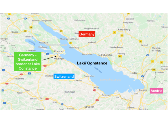
Lake Constance is situated between the countries of Austria, Switzerland, and Germany. The German states of Bavaria and Baden-Württemberg, the Swiss cantons of St. Gallen, Thurgau, and Schaffhausen, and the Austrian state of Vorarlberg all have shorelines on it.
The lingua franca around Central Europe's third-largest lake is German, but when it comes to watery jurisdiction, all three nations agree to disagree. The borders of Austria, Switzerland, and Germany arrive at the lakeshore with precision, only to vanish when they hit the water.
Because no treaty has ever been reached to divide the lake, specific local issues such as fishing rights and boat licensing must be resolved through individual agreements.
This area is well-known for its sightseeing, water sports, winter sports such as skiing, summer sports such as swimming (sport), sailing, and recreation. It is also one of the few places in the world where modern Zeppelin airships operate, with 12-14 people able to take a trip above the lake around various points of interest.
10. Haskell Free Library and Opera House, U.S./Canada Border
 |
| Photo: Library Road Trip |
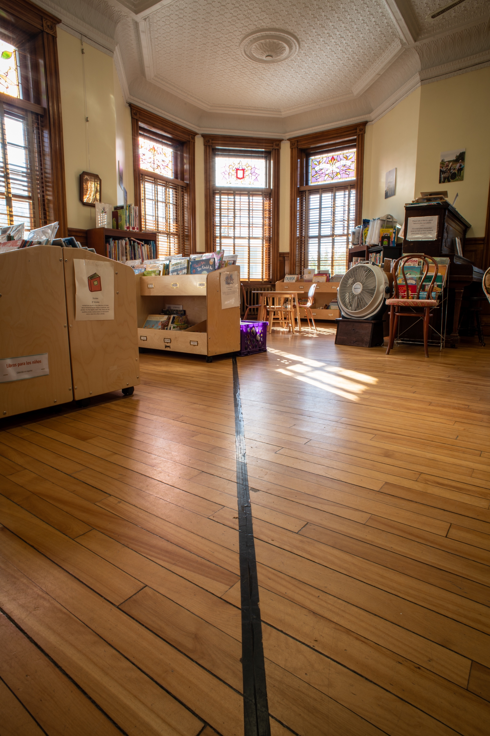
The Haskell Free Library and Opera House is located on the border of Vermont, the United States, and Quebec, Canada. You can enter from either side of the border, but you cannot exit from the other. Otherwise, you will be fined and possibly arrested.
The Haskell Free Library and Opera House (French: Bibliothèque et salle d'opéra Haskell) is a Victorian structure that spans the Canada-United States border in Rock Island (now part of Stanstead), Quebec and Derby Line, Vermont. The Opera House, which was purposefully built on the international border, opened on June 7, 1904. Both countries designated it as a heritage structure in the 1970s and 1980s.
The library is located at 93 Caswell Avenue in Derby Line, Vermont, and 1 rue Church (Church Street) in Stanstead, Quebec.
The library and the opera stage are in Stanstead, but the main entrance and the majority of the opera seats are in Derby Line. As a result, the Haskell is sometimes referred to as "the only library in the United States of America," and visitors must enter the building through the United States entrance. Patrons from Canada are permitted to enter the United States door without reporting to customs by following a prescribed route through the sidewalk of rue Church (Church Street), as long as they return to Canada immediately after leaving the building by following the same route.
The library has over 20,000 books in French and English and is open to the public 38 hours per week.
Both countries recognize the structure as a historic site. It has been listed on the National Register of Historic Places in the United States since 1976. It was designated a National Historic Site in Canada in 1985 and a provincial heritage site in 1977.
Following Trump's travel ban, the library served as a venue for international reunions due to its location in both Canada and the United States.
Related: Which Canadian Provinces Border With The United States?
11. Zipline Connects Spain And Portugal
 |
| Photo: Limitzero |
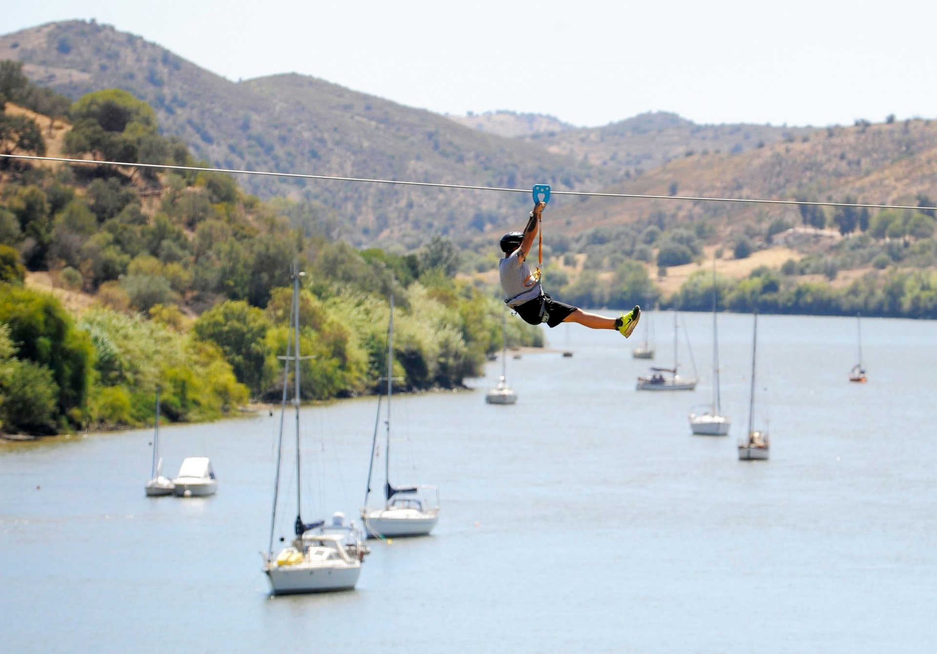
The world's first cross-border zip line is located in Sanlcar de Guadiana, Spain. Limite Zero runs between Sanlcar de Guadiana in Spain and Alcoutim in Portugal. It spans the Guadiana River at a height of 50 feet above sea level.
This amazing experience involves not only traveling from one country to another in less than one minute, but also time travel. Spain and Portugal have different time zones. If you leave the coast of Spain at 4 p.m., you will arrive in Portugal at 3 p.m. This is a one-of-a-kind border crossing experience, with no lines or passport checks.
During your zip line ride, you can see beautiful scenery. To complete the journey, no training is required because all instructions are provided on-site. There will be people to assist you at both the departure and arrival platforms, so all you have to do is follow the instructions and have fun.
The operating season runs from late March to early December. When they operate on a daily basis, the months of July to mid-September are the busiest. It is best to book ahead of time during this time. The zip line is closed on Mondays and Tuesdays during the rest of the year.
12. Poland/ Ukraine Border
 |
| Photo: Wikipedia |
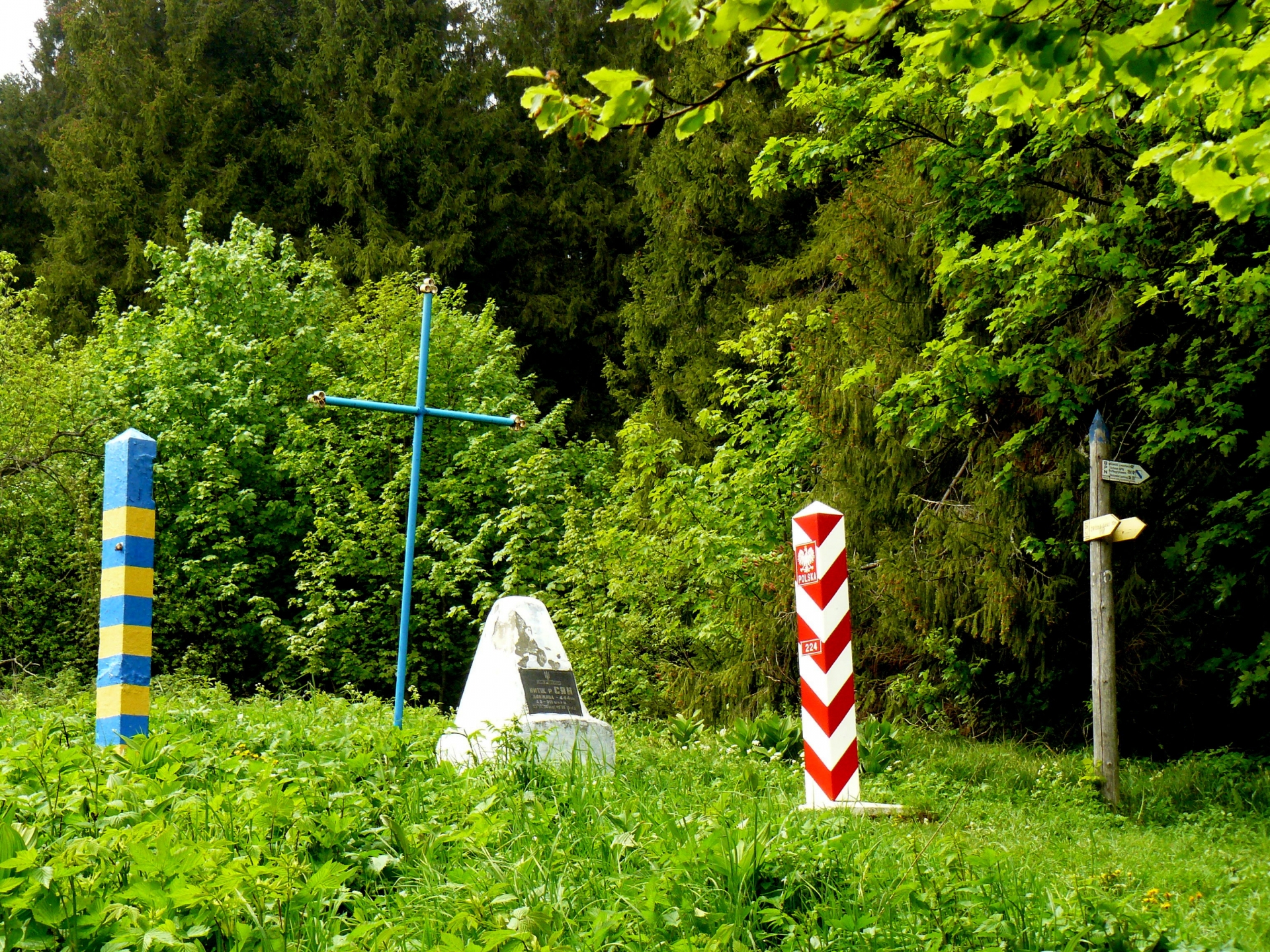
Poland's and Ukraine's state border is the Poland-Ukraine border. It spans 535 kilometers (332 miles) or 529 kilometers (329 miles).
The Poland-Ukraine border is the EU's most frequently crossed eastern border.
The vast majority of border traffic is generated by Ukrainian citizens. Petty trade and shopping tourism were and continue to drive much of the traffic, with migration for labor purposes also playing a role.
The border is heavily patrolled because it is a major smuggling route into the EU for both goods and illegal immigrants.
The border area is home to approximately 8 million people, roughly equally divided between Poland and Ukraine.
 50+ Weirdest & Little-Known Facts About Ukraine 50+ Weirdest & Little-Known Facts About Ukraine |
13. Dominican Republic–Haiti border
 |
| Photo: Bored Panda |
On the island of Hispaniola, the Dominican Republic and the Republic of Haiti share an international border known as the Dominican Republic–Haiti border. The 391 km border was established by the 1929 Dominican-Haitian border treaty, and it runs from the Caribbean Sea in the south to the Atlantic Ocean in the north.
The island was initially split formally in 1697 as part of the Ryswick Peace, which saw Spain give France the western part of the island that it had forcibly taken earlier in the century. England attempted, but was unsuccessful, to conquer the entire island in 1621. Both nations were occupied by the United States in the early 20th century, during which time the border was altered significantly. About two thirds of the island are in the Dominican Republic, and the remaining third is in the Republic of Haiti.
Immediately west of the Dominican town of Pepillo Salcedo, at the point where the Dajabón River (Rivière du Massacre) enters Manzanillo Bay, is where the border begins in the north at the Boca del Río Dajabón. After briefly following this river to the south, the border then travels in a series of straight lines through the Laguna de Saladillo to the south, where it rejoins the same river between Dajabón (DR) and Ouanaminthe (Haiti). After that, the border once more follows the river south to Vara de Vaca, a Dominican village. Here, the river is also referred to as the Río Capatillo/Bernar (Rivière de Capotille/Bernard). After that, the border travels overland to the west before abruptly turning southeast when it reaches the Libón River. It follows the river all the way to the DR-45 road, which it then takes south through the mountains for a while until it reaches the Artibonite River. The border then proceeds to the southwest along the Artibonite until it meets the Macasía River, then proceeds east along this river. The border then travels south and southeast overland via a number of straight-line sections, crossing the Rivière Carrizal momentarily in the process. After that, it heads west toward Granada before veering southeast to run parallel to the Etang Saumâtre lake, crossing it briefly along the way. The boundary wraps around the southeast corner of the lake and then travels straight south-east and then south-west overland. It then temporarily follows the Río Bonito southward before arriving at the Pedernales River. It then proceeds south along this river all the way to the Caribbean Sea.
14. USA - Mexico Border
 |
| Photo: CNN |
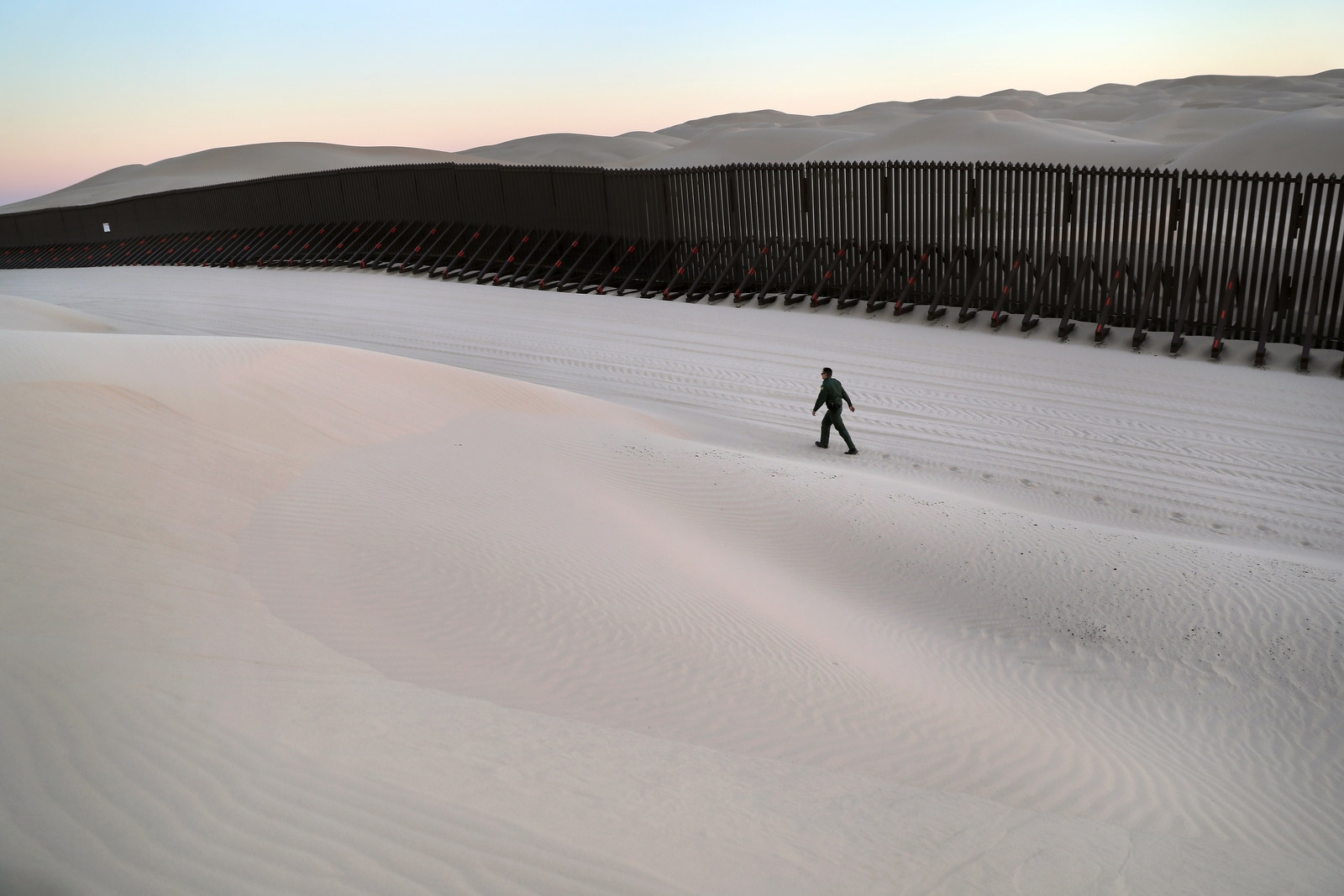
There is high double fencing between San Diego and Tijuana, Mexico, to deter people from crossing illegally. A section of the fence runs right through the beach and into the Pacific Ocean.
In Texas, there is frequently no fencing at all. The Rio Grande and the surrounding rugged terrain act as a natural barrier.
In between are various fences of various shapes, sizes, and materials. These fences do not all join together to form a single continuous line. Some areas do not have any fencing at all.
Related: Which Countries Border With The United States?
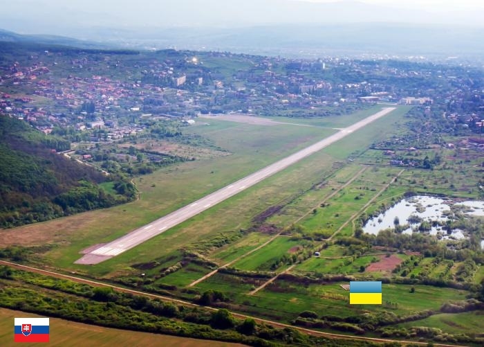
15. Ukraine & Slovakia (Uzhorod International Airport)
 |
| Photo: Bored Panda |
The Slovakia-Ukraine border is a legally recognized border between Slovakia and Ukraine. Both countries inherited it from their previous governments, Ukraine from the Soviet Union and Slovakia from Czechoslovakia.
The current border, which stretches for 97 kilometers (60 miles), was established after World War II. Following Slovakia's admission to the European Union, the border became the EU's external border.
16. The DMZ, North Korea/South Korea
 |
| Photo: Wkipedia |
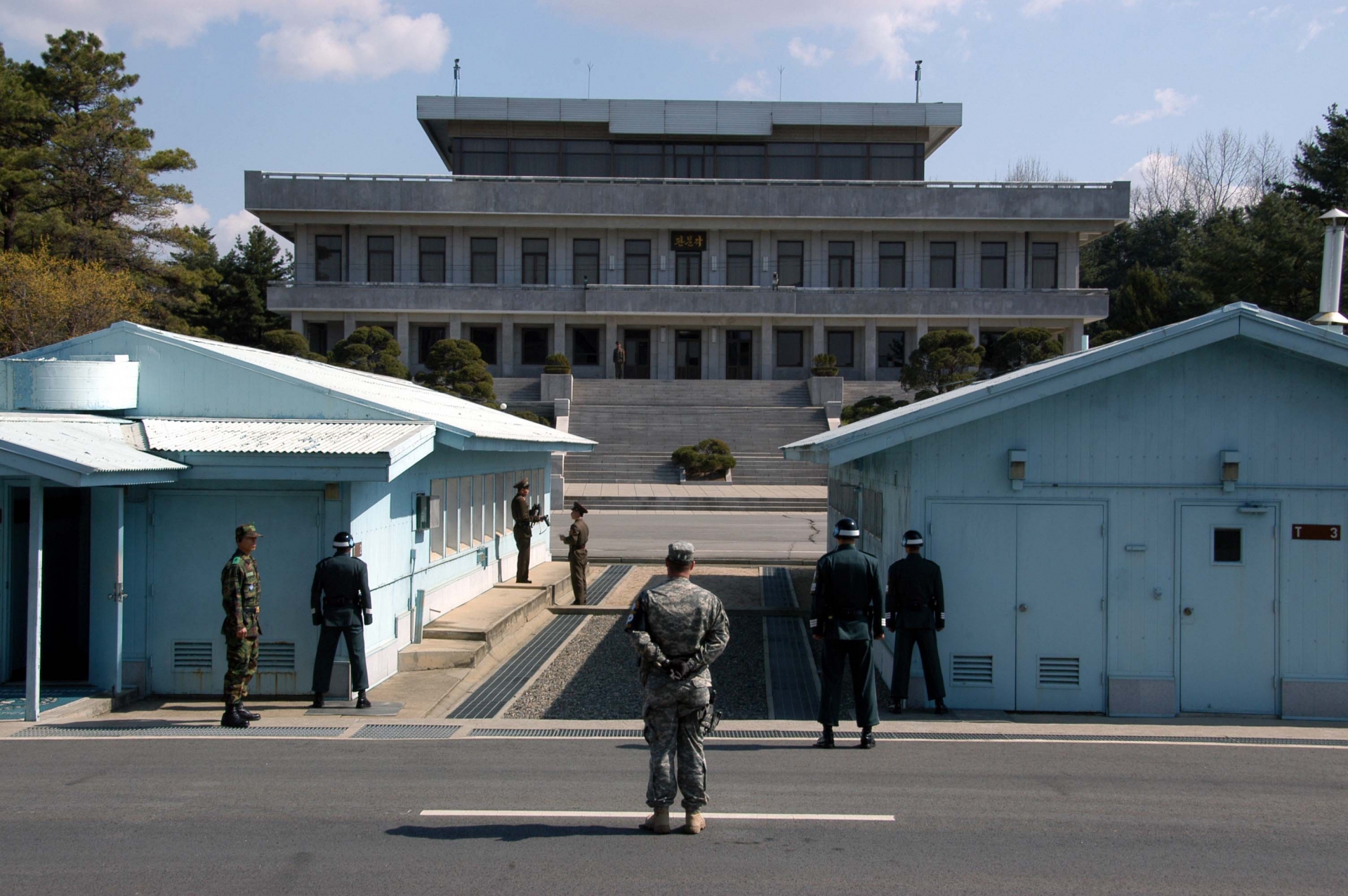
The Korean Demilitarized Zone (Hanbando Bimujang Jidae) is a strip of land that runs across the Korean Peninsula near the 38th parallel north. The demilitarized zone (DMZ) is a border barrier that roughly splits the peninsula in half. It was established in 1953 under the provisions of the Korean Armistice Agreement, an agreement between North Korea, China, and the United Nations Command, to serve as a buffer zone between the countries of North Korea and South Korea.
The DMZ stretches for 250 kilometers (160 miles) and is about 4 kilometers (2.5 miles) wide. Several incidents have occurred in and around the DMZ, with both military and civilian casualties on both sides. The small Joint Security Area (JSA) near the western end of the DMZ serves as a meeting point for the two nations, where negotiations take place.
 12 Most Popular Holidays and Festivals in North Korea 12 Most Popular Holidays and Festivals in North Korea |
17. Estonia/ Russia Border
 |
| Russia (left) And Estonia (right). Photo: Bored Panda |
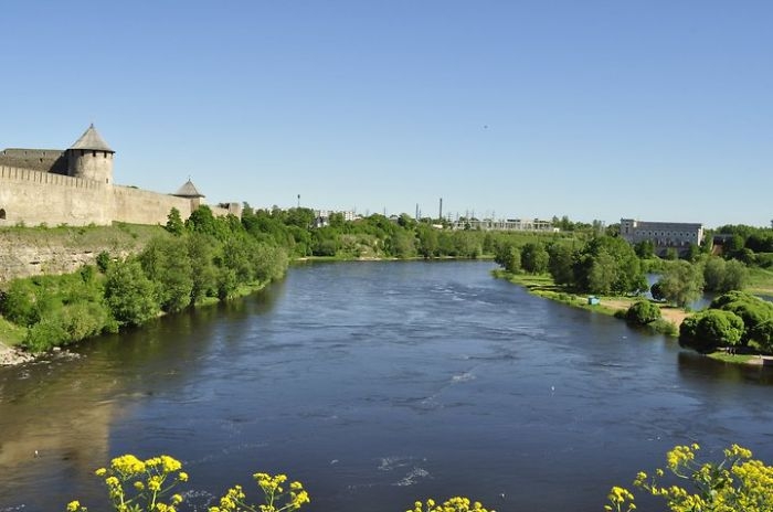
The international border between the Republic of Estonia (EU member) and the Russian Federation (CIS member) is known as the Estonia-Russia border. The border spans 294 kilometers (183 miles). It arose in 1918, following Estonia's declaration of independence from Russia. The border mostly follows national, administrative, and ethnic lines that have gradually formed since the 13th century. The exact location of the border was a source of contention between Estonia and Russia, which was settled with the signing of the Border Agreement, but neither Russia nor Estonia has completed ratification. It is a European Union external border.
18. Vatican City, Vatican/Italy
 |
| The border between Italy and the Vatican City State, at St. Peter’s Square. Photo: Quora |
The Holy See's independent city-state is Vatican City, officially Vatican City State (Italian: Stato della Città del Vaticano). Because of its location as an urban, landlocked enclave of Rome, Italy, Vatican City has a distinct geography. It is the world's smallest independent state, covering only 49 hectares. Outside of the Vatican City, thirteen buildings in Rome and the Pope's summer residence, Castel Gandolfo, have extraterritorial rights. (One structure, the Paul VI Audience Hall, spans the border, but the Italian portion has extraterritorial rights.)
The Vatican border is the world's shortest total boundary, measuring only 3.2 kilometers. The Vatican is frequently used as an example of an Enclave, which is a territory completely surrounded by the territory of another state, in this case Italy.
19. Hotel Arbez, France/Switzerland
 |
| Photo: Amusing Planet |
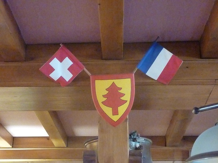
The Hotel Arbez, also known as the Hôtel Arbez Franco-Suisse, is a hotel located in the tiny village of La Cure, which is divided by the international border between France and Switzerland. The structure was originally used as a grocery store (its Swiss portion) and a pub (its French half) by a private landowner and businessman to take advantage of an impending border adjustment between the two countries. Today, the entire structure houses a hotel, with the boundary dividing the dining room, kitchen, and several rooms.
The Hotel Arbez's unusual situation arose from a dispute between France and Switzerland over ownership of the Vallée des Dappes, which lies just south and west of the tiny town of La Cure. Though the valley had little territorial value, it provided a convenient military route between France and Savoy. Napoleonic France annexed it in 1802, but the Congress of Vienna returned it to Switzerland, despite French calls for its return. After several attempts to acquire the area were rebuffed by the Swiss, France decided in 1862 to offer a nearby section of comparable size of its own territory in exchange. The Swiss agreed, and a treaty was signed in Bern that transferred ownership of slightly less than 8 square kilometers (3 square miles). While La Cure had previously been entirely within France, the new boundary was set to split the village in half, including some residences and a pub. The treaty required that any existing structure bisected by the border be left alone, which sparked an idea in one local businessman.
20. Llivia, Spain/France
 |
| Photo: Amusing Planet |
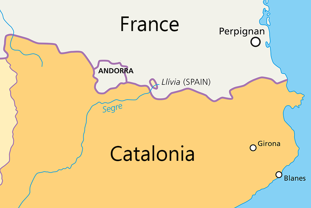
Llvia is a town in the Cerdanya comarca, Girona province, Catalonia, Spain. It is a Spanish exclave surrounded by the French Pyrénées-Orientales département. The municipality of Llvia had a total population of 1,589 people in 2009. It is separated from the rest of Spain by a 1.6-kilometer-wide corridor that includes the French communes of Ur and Bourg-Madame.
Llivia is about eight square miles in size and has a population of around 1500 people. Llivia, like Gibraltar, is a historical and cartographic anomaly.
With the exception of a few transactions with France, this enclave is separated from Spain by a 2km corridor that includes the French villages of Ur and Bourg-Madame.
While this may not seem remarkable to those who are used to crossing borders for lunch in Europe, a cheeky indulgence we quite enjoy, the small village nature of this country within a country with no discernible border makes it quite unique.
Top 10 Countries With the Most Borders
1.Russia
Number of unique land neighbours: 14
Total length of borders: 20,017km
Neighbours: Azerbaijan, Belarus, China, Estonia, Finland, Georgia, Kazakhstan, North Korea, Latvia, Lithuania, Mongolia, Norway, Poland, Ukraine.
2.Brazil
Number of unique land neighbours: 10
Total length of borders: 14,691km
Neighbours: Argentina, Bolivia, Colombia, French Guiana, Guyana, Paraguay, Peru, Suriname, Uruguay, Venezuela.
3.Democratic Republic of the Congo
Number of unique land neighbours: 9
Total length of borders: 10,730km
Neighbours: Angola, Burundi, Central African Republic, Republic of the Congo, Rwanda, South Sudan, Tanzania, Uganda, Zambia
4.Germany
Number of unique land neighbours: 9
Total length of borders: 3,621km
Neighbours: Austria, Belgium, Czech Republic, Denmark, France, Luxembourg, Netherlands, Poland, Switzerland.
5.France
Number of unique land neighbours: 8
Total length of borders: 2,889km
Neighbours: Andorra, Belgium, Germany, Italy, Luxembourg, Monaco, Spain, Switzerland
6.Austria
Number of unique land neighbours: 8
Total length of borders: 2,562km
Neighbours: Czech Republic, Germany, Hungary, Italy, Liechtenstein, Slovakia, Slovenia, Switzerland
7.Zambia
Number of unique land neighbours: 8
Total length of borders: 5,667km
Neighbours: Angola, Botswana, Democratic Republic of the Congo, Malawi, Mozambique, Namibia, Tanzania, Zimbabwe.
8.Turkey
Number of unique land neighbours: 8
Total length of borders: 2,648km
Neighbours: Armenia, Azerbaijan, Bulgaria, Georgia, Greece, Iran, Iraq, Syria.
9.Tanzania
Number of unique land neighbours: 8
Total length of borders: 3,861km
Neighbours: Burundi, Democratic Republic of the Congo, Kenya, Malawi, Mozambique, Rwanda, Uganda, Zambia
10.Serbia
Number of unique land neighbours: 8
Total length of borders: 2,027km
Neighbours: Bosnia and Herzegovina, Bulgaria, Croatia, Hungary, Kosovo, Macedonia, Montenegro, Romania
The World's Longest Borders
The most populous nation on the planet has 16 unique land neighbours, with 22,147km of land borders (also a record).
They are: Afghanistan (76km), Bhutan (470km), Hong Kong (30km), India (3 borders totalling 3,380km), Kazakhstan (1,533km), North Korea (1,416km), Kyrgyzstan (858km), Laos (423km), Macau (0.34km), Mongolia (4,677km), Myanmar (2,185km), Nepal (1,236km), Pakistan (523km), Russia (2 borders totalling 3,645km), Tajikistan (414km) and Vietnam (1,281km).
Conclusion
Many of us picture fortified fences or armed guards at the mental picture of a border. You are aware, however, that the world is full of borders both strange and beautiful beyond these arbitrary ones.
Nature or man can establish international boundaries between nations. But it must be admitted that they have really become a connecting thread, a gift for people between countries.
These odd and fascinating borders have long attracted tourists from all over the world. Explore these odd confines if only once in your life.
 What Are The First War Ships of US Navy - Top 10 Oldest What Are The First War Ships of US Navy - Top 10 Oldest This article profiled 10 of the oldest consequential warships of the US Navy in American history. |
 Top 10 Largest Warships in the World of All Time Top 10 Largest Warships in the World of All Time Read on to find out about the largest ships in the world, the size of these behemoth boats will completely surprise you! |
 What are the First Aircraft Carrier of America - Top 10 Oldest What are the First Aircraft Carrier of America - Top 10 Oldest This article collected the name of each oldest aircraft carrier manufactured in America and when it was commissioned. |
 Top 10 Best and Hottest Hairstyles for Summer Travel Top 10 Best and Hottest Hairstyles for Summer Travel There are a few hairstyles for women you probably don’t know of yet, but they will save your hair while traveling. Check out top 5 ... |


