How Many Regions Are There In the U.S?
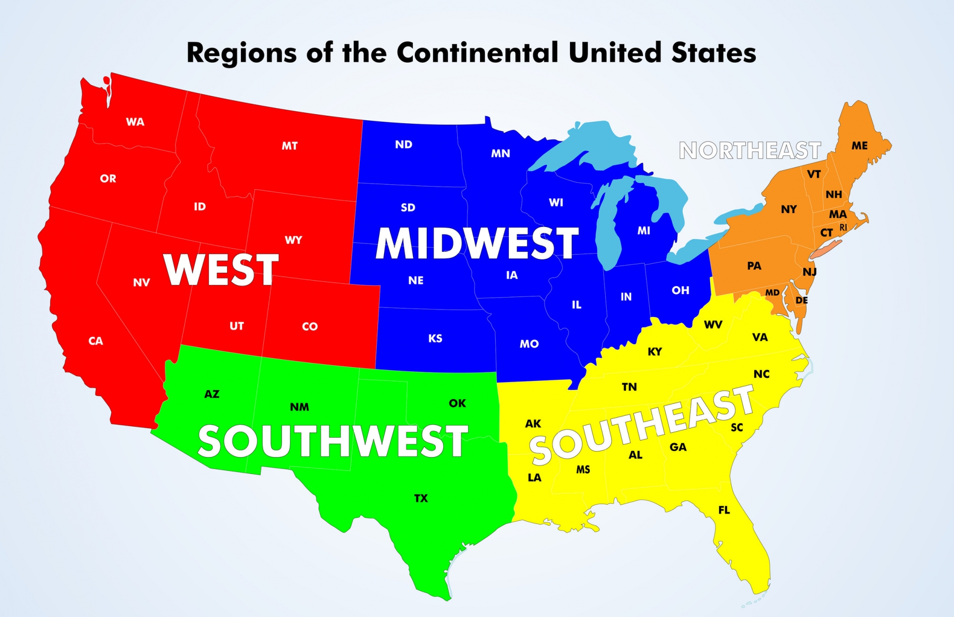 |
| How many Regions Are There In the U.S? Photo: Mappr |
The United States of America is a country made up of 50 States and 1 Federal District. These states are then divided into 5 geographical regions: the Northeast, the Southeast, the Midwest, the Southwest, and the West, each with different climates, economies, and people.
What is Region?
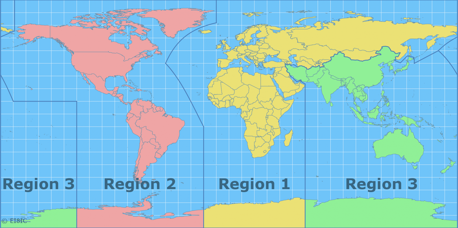 |
| Photo: MapAbility |
In geography, regions are areas that are broadly divided by physical characteristics (physical geography), human impact characteristics (human geography), and the interaction of humanity and the environment (environmental geography). Geographic regions and sub-regions are mostly described by their imprecisely defined, and sometimes transitory boundaries, except in human geography, where jurisdiction areas such as national borders are defined in law.
Apart from the global continental regions, there are also hydrospheric and atmospheric regions that cover the oceans, and discrete climates above the land and water masses of the planet. The land and water global regions are divided into subregions geographically bounded by large geological features that influence large-scale ecologies, such as plains and features.
As a way of describing spatial areas, the concept of regions is important and widely used among the many branches of geography, each of which can describe areas in regional terms. For example, ecoregion is a term used in environmental geography, cultural region in cultural geography, bioregion in biogeography, and so on. The field of geography that studies regions themselves is called regional geography.
In the fields of physical geography, ecology, biogeography, zoogeography, and environmental geography, regions tend to be based on natural features such as ecosystems or biotopes, biomes, drainage basins, natural regions, mountain ranges, soil types. Where human geography is concerned, the regions and subregions are described by the discipline of ethnography.
A region has its own nature that could not be moved. The first nature is its natural environment (landform, climate, etc.). The second nature is its physical elements complex that was built by people in the past. The third nature is its socio-cultural context that could not be replaced by new immigrants.
Regions of the U.S.
Regions are parts of the country that are grouped together based on geographical location. In the United States, there are many regions that make up the country's landscape. The primary regional areas are categorized as North, South, West, and Midwest. However, you may come across information that classifies the regions into additional categories. For example, some northern states are known as New England states while other common groupings include the Middle Atlantic, Rocky Mountain, Southwestern, Pacific Northwest, and Atlantic regions. For the purposes of this lesson, we will focus on the North, South, West, and Midwest regions.
Government agencies have different ways of grouping the states based on geography, culture, and other factors. This grouping of regions is based on the Core Knowledge Sequence that describes the shared knowledge that all children should learn in U.S. schools.
Across the nation, the landscape varies widely from tropical beaches in Florida, rolling prairies in the Midwest, high peaks in the Rocky Mountains, barren deserts in the West and dense wilderness areas in the Northeast and Northwest. Interspersed in between are the Great Lakes and the Mississippi River in the Midwest, the Grand Canyon in the Southwest, the majestic Yosemite Valley and Yellowstone in the West, and numerous other natural wonders. And, like its geography, the weather of the United States also varies widely from tropical in Hawaii and Florida, arctic in Alaska, semiarid in the plains west of the Mississippi River and arid in the Great Basin of the southwest.
Which are the regions of the U.S?
1. New England of the U.S and Full List of States
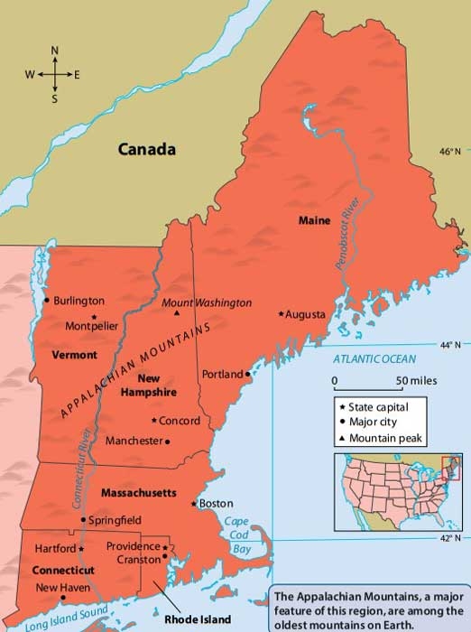 |
| Photo: Legends of America |
States:
Connecticut
Maine
Massachusetts
New Hampshire
Rhode Island
Vermont
New England is a northeastern region of the United States comprising the states of Connecticut, Maine, Massachusetts, New Hampshire, Rhode Island, and Vermont.
In 1616, English explorer John Smith named the region “New England”. The name was officially sanctioned on November 3, 1620, when the charter of the Virginia Company of Plymouth was replaced by a royal charter for the Plymouth Council for New England, a joint-stock company established to colonize and govern the region.
The geography of this region is diverse for such a small area, which includes forested mountains, coastal plains, rolling hills, and the northern end of the Appalachian Mountains. It was here that the first Europeans settled in what would become the United States, including the pilgrims at Plymouth Harbor, Massachusetts who celebrated the nation’s first Thanksgiving in 1620. New England is home to Acadia National Park in Maine and the Cape Cod National Seashore in Massachusetts. Rhode Island is the nation’s smallest state.
Although the smallest region geographically and one not blessed with large expanses of rich farmland or a mild climate, New England played a dominant role in American development. From the 17th century until well into the 19th, New England was the country’s cultural and economic center.
The earliest European settlers of New England were conservative English Protestants, many of whom came in search of religious freedom. They gave the region its distinctive political format—the town meeting (an outgrowth of meetings held by church elders) in which citizens gathered to discuss the issues of the day. Even though only men who owned property could vote, town meetings afforded New Englanders an unusually high level of participation in government. Such meetings still function in many New England communities today, although of course they now include women.
New Englanders found it difficult to farm the land in large lots, as was common in the South. By 1750, therefore, many settlers had turned to other pursuits. The mainstays of the region became shipbuilding, fishing, and trade. In their business dealings, New Englanders gained a reputation for hard work, shrewdness, thrift, and ingenuity. These traits were useful as the Industrial Revolution reached America in the first half of the 19th century. In Massachusetts, Connecticut, and Rhode Island, for example, new factories sprang up to manufacture goods such as clothing, rifles, and clocks. Most of the money to run these businesses came from Boston, which was the financial heart of the nation.
In recent times, this populous region has lost many of its industries to states or foreign countries where goods can be made more cheaply. The region’s economy has, however, rebounded with the growth of the microelectronics, computer, and biotech industries. Education, high technology, financial services, tourism, and medicine continue to drive the regional economy.
New England has always supported a vibrant cultural life, with institutions like the Boston Symphony Orchestra and the Museum of Fine Arts. Education is another of the region’s strongest legacies. Its cluster of top-ranking universities and colleges is unequaled by any other region. These top schools include Harvard, Yale, Brown, Dartmouth, Wellesley, Smith, Mt. Holyoke, Williams, Amherst, and Wesleyan, to name but a few.
An important historical literary work from this region is Thoreau’s Walden; or, Life in the Woods. New England was also home to poets Emily Dickinson and later Robert Frost, as well as to Harriet Beecher Stowe, whose Uncle Tom’s Cabin is credited with having given impetus to the abolitionist movement.
As some of the original New England settlers migrated westward, immigrants from Canada, Ireland, Italy, and Eastern Europe moved into the region. Despite a changing population, much of the original spirit of New England remains. This can be seen in the simple wood-frame houses and white church steeples that are features of many small towns, and in the traditional lighthouses that dot the Atlantic coast.
New England is famous for foods like clam chowder, Maine lobsters, Vermont maple syrup, turkey, Boston baked beans, and Boston cream pie.
Boston, Massachusetts, the largest metropolitan area in the region, pre-dates the American Revolution, and its Freedom Trail passes sites that were critical to the nation’s founding.
2. Northeast of the U.S and Full List of States
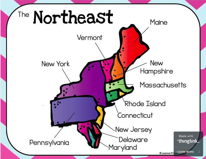 |
| Photo: Quizlet |
The states of this region include:
- Massachusetts
- Rhode Island
- Connecticut
- Vermont
- New Hampshire
- Maine
- Pennsylvania
- New Jersey
- New York
The Northeastern United States (also referred to as the American Northeast, the Northeast, and the East Coast) is a geographical region of the United States. On the Atlantic coast of North America, Canada is to its North, the Southern United States is to its south, and to its west is the Midwestern United States. The Northeast is one of the four regions defined by the United States Census Bureau for the collection and analysis of statistics.
The Census Bureau–defined region has a total area of 181,324 sq mi (469,630 km2) with 162,257 sq mi (420,240 km2) of that being land mass. Although it lacks a unified cultural identity, the Northeastern region is the nation's most economically developed, densely populated, and culturally diverse region. Of the nation's four census regions, the Northeast has the second-largest percentage of residents living in an urban setting, with 85 percent, and is home to the nation's largest metropolitan area. The Northeast is home to most of the Northeast megalopolis, the most economically significant and second most-populated of eleven mega regions within the United States, accounting for 20% of US GDP.
Geographically there is some debate as to where the Northeastern United States begins and ends. The vast area from central Virginia to northern Maine, and from western Pennsylvania (Pittsburgh) to the Atlantic Ocean, have all been loosely grouped into the Northeast at one time or another. Much of the debate has been what the cultural, economic and urban aspects of the Northeast are, and where they begin or end as one reaches the borders of the region.
Using the Census Bureau's definition of the Northeast, the region includes ten states: they are Maine, New York, New Jersey, Delaware, Vermont, Massachusetts, Rhode Island, Connecticut, New Hampshire, and Pennsylvania. The region is often subdivided into New England (the six states east of New York State) and the Mid-Atlantic states (New York, New Jersey, and Pennsylvania). This definition has been essentially unchanged since 1880 and is widely used as a standard for data tabulation. However, the Census Bureau has acknowledged the obvious limitations of this definition and the potential merits of a proposal created after the 1950 census, that would include changing regional boundaries to include Delaware, Maryland, and the District of Columbia with the Mid-Atlantic states, but ultimately decided that "the new system did not win enough overall acceptance among data users to warrant adoption as an official new set of general-purpose State groupings. The previous development of many series of statistics, arranged and issued over long periods of time on the basis of the existing State groupings, favored the retention of the summary units of the current regions and divisions." The Census Bureau confirmed in 1994 that it would continue to "review the components of the regions and divisions to ensure that they continue to represent the most useful combinations of States and State equivalents."
Many organizations and reference works follow the Census Bureau's definition for the region. In the history of the United States, the Mason–Dixon line between Pennsylvania (the North) and Maryland (the South) traditionally divided the regions, but in modern times, various entities define the Northeastern United States in somewhat different ways. The Association of American Geographers divides the Northeast into two divisions: "New England", which is the same as the Census Bureau; and it has the same "Middle States" but adds Delaware. Similarly, the Geological Society of America defines the Northeast as these same states but with the addition of Maryland and the District of Columbia. The narrowest definitions include only the states of New England. Other more restrictive definitions include New England and New York as part of the Northeast United States, but exclude Pennsylvania and New Jersey.
The climate of the Northeastern United States varies from northernmost Maine to southernmost Maryland. The climate of the region is created by the position of the general west to east flow of weather in the middle latitudes that much of the USA is controlled by and the position and movement of the subtropical highs. Summers are normally warm in northern areas to hot in southern areas. In summer, the building Bermuda High pumps warm and sultry air toward the Northeast, and frequent (but brief) thundershowers are common on hot summer days. In winter the subtropical high retreats southeastward, and the polar jet stream moves south bringing colder air masses from up in Canada and more frequent storm systems to the region. Winter often brings both rain and snow as well as surges of both warm and cold air.
The basic climate of the Northeast can be divided into a colder and snowier interior (western Maryland, most of Pennsylvania, most of northern New Jersey, Upstate New York, and most of New England), and a milder coast and coastal plain from Cape Cod and southern Rhode Island southward, including Long Island, New Haven, New York City, Trenton, Philadelphia, Wilmington, and Baltimore. In the latter region the hardiness zones are 7a and 7b. Annual mean temperatures range from the low 50s F from Maryland to southern Connecticut, to the 40s F in most of New York State, New England and northern Pennsylvania. Most of the Northeast has a humid continental climate (Dfa/Dfb). The region's humid subtropical zone (Cfa/Do) begins on Martha's Vineyard and Long Island and extends southward through central and eastern Maryland. The oceanic climate (Cfb/Do) only exists on Block Island and Nantucket.
3. Southeast of the U.S and Full List of States
 |
| Photo: Mappr |
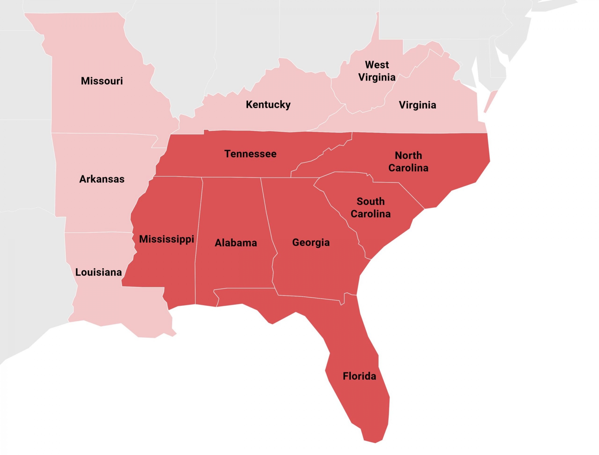
The states of this region include:
- Washington DC ( federal district)
- Georgia
- North Carolina
- South Carolina
- Virginia
- West Virginia
- Kentucky
- Tennessee
- Mississippi
- Alabama
- Delaware
- Maryland
- Florida
- Louisiana
- Arkansas
The southeastern United States, also referred to as the American Southeast or simply the Southeast, is broadly the eastern portion of the southern United States and the southern portion of the eastern United States. It comprises at least a core of states on the lower East Coast of the United States and eastern Gulf Coast. Expansively, it includes everything south of the Mason–Dixon line and Ohio River, stretching as far west as Arkansas and Louisiana, and as far north as West Virginia and Maryland. There is no official U.S. government definition of the region, though various agencies and departments use different definitions.
The U.S. Geological Survey considers the Southeast region to be the states of Alabama, Florida, Georgia, Arkansas, Kentucky, Louisiana, Mississippi, North Carolina, South Carolina, and Tennessee, plus Puerto Rico and the United States Virgin Islands.
There is no official Census Bureau definition of the southeastern United States. They instead divide a larger region which includes Texas, Oklahoma, Maryland, Delaware, Virginia and West Virginia, designated as "the South" into three separate subregions, none of which are conventionally considered to define the Southeast.
The nonprofit American Association of Geographers defines the Southeastern United States as Alabama, Florida, Georgia, Kentucky, Maryland, Mississippi, North Carolina, South Carolina, Tennessee, Virginia and West Virginia. The OSBO (Organization Supporting Business Owners) uses the same states, but includes Arkansas and Louisiana. The states of Delaware and Missouri, along with the U.S. capital of Washington, D.C., are also sometimes added in definitions of the term.
Most of the southeastern part of the United States is dominated by the humid subtropical climate (Cfa/Cwa). As one nears the southern portion of Florida, the climate gradually becomes tropical, as the winter season and all months have a mean temperature above 64.4 °F (18.0 °C) (the defined coldest monthly mean temperature of tropical climates).
Seasonally, summers are generally hot and humid throughout the entire region. The Bermuda High pumps hot and moist air mass from the tropical Atlantic Ocean and eastern Gulf of Mexico westward toward the southeast United States, creating the typical sultry tropical summers. Daytime highs are often in the upper 80s to lower 90s F. Rainfall is summer concentrated along the Gulf Coast and the South Atlantic coast from Norfolk, Virginia southward, reaching a sharp summer monsoon-like pattern over peninsular Florida, with dry winters and wet summers. Sunshine is abundant across the southeastern United States in summer, as the rainfall often comes in quick, but intense downpours. The mid-South, especially Tennessee, and the northern halves of Mississippi, Alabama, and Georgia, have maximum monthly rainfall amounts in winter and spring, owing to copious Gulf moisture and clashes between warm, moist air from the Gulf of Mexico and cold, dry air from Canada during the cold season. In this area, December, March, or April are typically the wettest months; August to October, the driest months (for example, in Tupelo, MS, Huntsville, AL and Memphis, TN).
Winters are cool in the northern areas like Tennessee, Virginia, Maryland, and western North Carolina, with average highs in the 45 °F (7 °C) range in January. Farther south, winters become milder across interior eastern North and South Carolina, Georgia, and Alabama, with average January highs in the 53 °F (12 °C) range. As one nears the Gulf of Mexico, coastal plain, and coastal areas of Georgia and the Carolinas, winters become warm, with daytime highs near or over 60 °F (16 °C), until far enough south in central Florida where daytime highs are above 70 °F (21 °C). Winters tend to be very dry and sunny across Florida, with a gradual increase in winter rainfall with increasing latitude, especially west of the Appalachian Mountains.
4. Midwest of the U.S and Full List of States
 |
| Photo: Wikipedia |
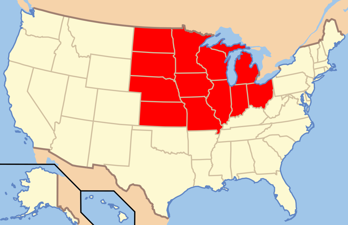
The states of this region include:
- Minnesota
- Wisconsin
- Illinois
- Ohio
- Indiana
- Michigan
- Missouri
- Iowa
- Kansas
- Nebraska
- North Dakota
- South Dakota
The Midwestern United States, also referred to as the Midwest or the American Midwest, is one of four census regions of the United States Census Bureau (also known as "Region 2"). It occupies the northern central part of the United States. It was officially named the North Central Region by the Census Bureau until 1984. It is between the Northeastern United States and the Western United States, with Canada to its north and the Southern United States to its south.
The Census Bureau's definition consists of 12 states in the north central United States: Illinois, Indiana, Iowa, Kansas, Michigan, Minnesota, Missouri, Nebraska, North Dakota, Ohio, South Dakota, and Wisconsin. The region generally lies on the broad Interior Plain between the states occupying the Appalachian Mountain range and the states occupying the Rocky Mountain range. Major rivers in the region include, from east to west, the Ohio River, the Upper Mississippi River, and the Missouri River. The 2020 United States census put the population of the Midwest at 68,995,685. The Midwest is divided by the Census Bureau into two divisions. The East North Central Division includes Illinois, Indiana, Michigan, Ohio, and Wisconsin, all of which are also part of the Great Lakes region. The West North Central Division includes Iowa, Kansas, Minnesota, Missouri, North Dakota, Nebraska, and South Dakota, several of which are located, at least partly, within the Great Plains region.
Chicago is the most populous city in the American Midwest and the third most populous in the United States. Chicago and its suburbs, together called Chicagoland, form the largest metropolitan area with 10 million people, making it the fourth largest metropolitan area in North America, after Greater Mexico City, the New York Metropolitan Area, and Greater Los Angeles. Other large Midwestern cities include (in order by population) Columbus, Indianapolis, Detroit, Milwaukee, Kansas City, Omaha, Minneapolis, Wichita, Cleveland, St. Paul, St. Louis, and Cincinnati. Large Midwestern metropolitan areas include Metro Detroit, Minneapolis–St. Paul, Greater St. Louis, Greater Cincinnati, the Kansas City metro area, the Columbus metro area, and Greater Cleveland.
The summers are hot and humid in this region. Winters are usually cold, with lots of snowfall. The region is known for its tornado outbreaks, too.
5. The West of the U.S and Full List of States
 |
| Photo: Story Board That |
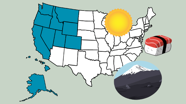
The states of this region include:
- California
- Colorado
- Nevada
- Hawaii
- Alaska
- Oregon
- Utah
- Idaho
- Montana
- Wyoming
- Washington
The Western United States (also called the American West, the Far West, and the West) is the region comprising the westernmost states of the United States. As American settlement in the U.S. expanded westward, the meaning of the term the West changed. Before about 1800, the crest of the Appalachian Mountains was seen as the western frontier. The frontier moved westward and eventually the lands west of the Mississippi River were considered the West.
The U.S. Census Bureau's definition of the 13 westernmost states includes the Rocky Mountains and the Great Basin to the Pacific Coast, and the mid-Pacific islands state, Hawaii. To the east of the Western United States is the Midwestern United States and the Southern United States, with Canada to the north, and Mexico to the south.
The West contains several major biomes, including arid and semi-arid plateaus and plains, particularly in the American Southwest; forested mountains, including three major ranges, the Sierra Nevada, the Cascades, and Rocky Mountains; the long coastal shoreline of the American Pacific Coast; and the rainforests of the Pacific Northwest.
The Western U.S. is the largest region of the country, covering nearly half the land area of the contiguous United States. It is also the most geographically diverse, incorporating geographic regions such as the temperate rainforests of the Northwest, the highest mountain ranges (including the Rocky Mountains, the Sierra Nevada, and the Cascade Range), numerous glaciers, and the western edge of the Great Plains. It also contains the majority of the desert areas located in the United States. The Mojave and Great Basin deserts lie entirely within the Western region, along with parts of the Sonoran and Chihuahuan deserts (the latter extends significantly into Texas). Given this expansive and diverse geography it is no wonder the region is difficult to specifically define. Sensing a possible shift in the popular understanding of the West as a region in the early 1990s, historian Walter Nugent conducted a survey of three groups of professionals with ties to the region: a large group of Western historians (187 respondents), and two smaller groups, 25 journalists and publishers and 39 Western authors. A majority of the historian respondents placed the eastern boundary of the West east of the Census definition out on the eastern edge of the Great Plains or on the Mississippi River. The survey respondents as a whole showed just how little agreement there was on the boundaries of the West.
Most of the region is arid, except for the Northwest, which has heavy rain and lush vegetation. The summers are typically hot, but winters are mild to cold, depending on the state. Colorado and Wyoming have cold and snowy weather. Southern California has hot weather all year. Mudslides and earthquakes are also common in California.
6. Southwest of the U.S and Full List of States
The states of this region include:
New Mexico
Arizona
Oklahoma
Texas
The Southwestern United States, also known as the American Southwest or simply the Southwest, is a geographic and cultural region of the United States that generally includes Arizona, New Mexico, and adjacent portions of California, Colorado, Nevada, Oklahoma, Texas, and Utah. The largest cities by metropolitan area are Phoenix, Las Vegas, El Paso, Albuquerque, and Tucson. Prior to 1848, in the historical region of Santa Fe de Nuevo México as well as parts of Alta California and Coahuila y Tejas, settlement was almost non-existent outside of Nuevo México's Pueblos and Spanish or Mexican municipalities. Much of the area had been a part of New Spain and Mexico until the United States acquired the area through the Treaty of Guadalupe Hidalgo in 1848 and the smaller Gadsden Purchase in 1854.
While the region's boundaries are not officially defined, there have been attempts to do so. One such definition is from the Mojave Desert in California in the west (117° west longitude) to Carlsbad, New Mexico in the east (104° west longitude), another says that it extends from the Mexico–United States border in the south to the southern areas of Colorado, Utah, and Nevada in the north (39° north latitude). Other definitions only contain the core Southwestern US states of Arizona and New Mexico; others focus on the land within the old Spanish and Mexican borders of the Nuevo México Province or the later American New Mexico Territory.
Distinct elements of the Western lifestyle thrive in the region, such as Western wear and Southwestern cuisines, including Native American, New Mexican, and Tex-Mex, or various genres of Western music like Indigenous, New Mexico, and Tejano music styles. Likewise with the sought-after Southwestern architectural styles in the region inspired by blending Pueblo and Territorial styles, with Mediterranean Revival, Spanish Colonial architecture, Mission Revival architecture, Pueblo Deco, and Ranch-style houses in the form of the amalgamated Pueblo Revival and Territorial Revival architectures. This is due to the region's influence by the Native American (especially Apache, Pueblo, and Navajo), Hispano, vaquero, and later American frontier cowboy history.
When looking at the fauna of the region, there is a broader definition of the American Southwest. The Southwestern Center for Herpetological Research defines the Southwest as being only the states of Arizona, New Mexico, with parts of California, Nevada, Texas, and Utah; although they include all of those six states in their map of the region, solely for ease of defining the border.
 What Is The Capital of Belgium: History, Facts, Best Places to See What Is The Capital of Belgium: History, Facts, Best Places to See The capital of Belgium has a rich history and plays an important role in Europe, and the world. We rounded up all things you need ... |
 What Is The Capital of Australia: History, Best Places to See and Facts What Is The Capital of Australia: History, Best Places to See and Facts Australia is one of those funny countries with a capital city that is not very well known or densely populated. We rounded up all things ... |
 Interesting Facts About Five Regions Of Asia Interesting Facts About Five Regions Of Asia Asia can be divided into five regions. These are Central Asia, East Asia, South Asia, Southeast Asia, and Western Asia. Check out this article to ... |
 The Full List of Countries and Regions in the World (Updated) The Full List of Countries and Regions in the World (Updated) What is the official name of your country? Which region is it located in? Check out our article to know whether you’ve got the ... |


