16 U.S Territories Around The World: Interesting Facts
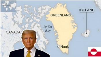 Where is Greenland: Why Trump’s renewed interest Where is Greenland: Why Trump’s renewed interest |
 Who is Múte Egede, Greenland’s Prime Minister, Who Said 'Not For Sale' Who is Múte Egede, Greenland’s Prime Minister, Who Said 'Not For Sale' |
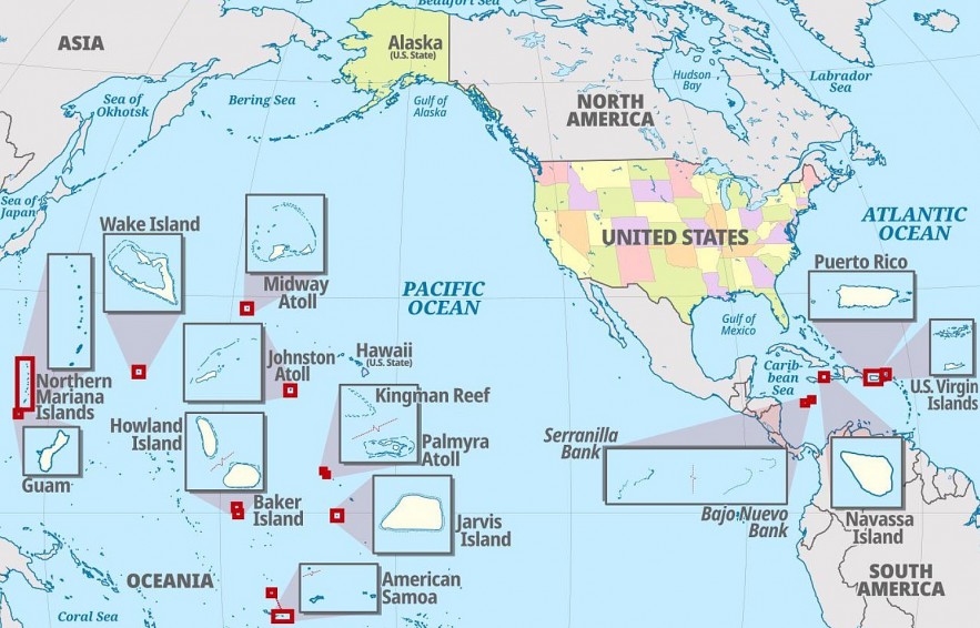 |
| US Territories in the World |
Most people know that the United States is made up of 50 states, but the nation also has 16 territories. Throughout history, the U.S. has had territories. Territories are land that is owned by the country but have not been admitted as states. A total of 32 territories have eventually become states.
The territories of the United States are administrative divisions that are directly overseen by the nation’s federal government. States of the U.S. share sovereignty with the federal government. However, territories do not share sovereignty. The United States federal government is allowed to explore, exploit, conserve, and manage all of its territories.
What are U.S territories?
The U.S. Territories refer to a group of geographical areas in the Pacific Ocean and Caribbean Sea. These territories fall under the jurisdiction of the United States federal government but do not hold the same status as the 50 states of the U.S. (e.g. they are not represented in the U.S. Congress). With varied histories, these territories often reflect a mix of American culture and different local cultures, providing a unique experience for international exchange participants. InterExchange programs provide an opportunity for international participants to live and work in some U.S. territories, most notably Guam and the Northern Mariana Islands.
Each island in the U.S. territories boasts unique geography, history, sites and customs, and offers experiences that are distinct from the other states. Outdoor activities, museums and historical attractions can be found throughout the U.S. territories, and international visitors will find no shortage of recreational activities.
The Establishment of a United States Territory and Its Governance
As many of the essays after the first states’ ratification of the Constitution have described, the way to statehood has typically been through first being a territory or part of a territory, and then seeking statehood. A territory is established by the passage of an organic act to organize it. Many have been enacted by Congress over the nation’s history, with the first being the Northwest Ordinance, passed in 1787 by the Continental Congress.
Current Major Territories and History
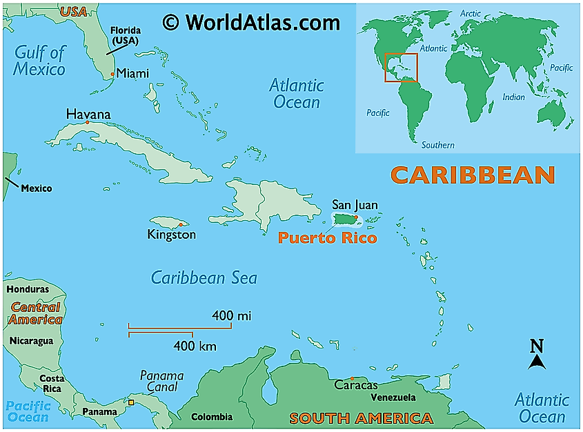 |
| Photo worldatlas |
Currently, the United States has five major U.S. territories: American Samoa, Guam, the Northern Mariana Islands, Puerto Rico, and the U.S. Virgin Islands. Each such territory is partially self-governing that exists under the authority of the U.S. government.
Pursuant to the Organic Act of 1900, or Foraker Act, Puerto Rico became a territory of the United States. Puerto Rico became a possession pursuant to the Spanish-American War. It has been a territory since that act passed. It has often been mentioned as a new state, but no serious effort has been made by Congress.
Pursuant to the Organic Act of the Virgin Islands of the United States of 1936, the United Stated added the U.S. Virgin Islands to its territories. In 1950, Guam became a territory pursuant to the Guam Organic Act of 1950. In 1954, the Revised Organic Act of the Virgin Islands replaced the original 1936 act.
The Northern Mariana Islands have been administered by the United States since Japan surrendered in World War II, pursuant to Security Council Resolution 21. The people of the Islands have by referendum voted to join with Guam, but in 1969, Guam rejected the proposal. American Samoa has no organic act, and as such is considered unorganized. Despite that, American Samoa has remained connected to the United States. In addition to the five major territories, the United States has a number of other territories that are uninhabited.
| Limitations of Territories Territories are not states and do not have full recognition that states enjoy. Notwithstanding not being states, each territory can send a delegate to the House of Representatives. With the exception of American Samoa, whose residents are U.S. nationals, those in the other four territories are U.S. citizens. Citizens of the territories can vote in primary elections for president, but they cannot vote in the general elections for president. In 2016, the Supreme Court of the United States held, in Puerto Rico v. Sanchez Valle, 579 U.S. ___ (2016), that territories do not have sovereignty. In the aftermath of Hurricane Maria, the Puerto Rico governor and others argued that the territories were powerless and had little understanding or support. As noted, they send delegates to the House, but have no vote, and cannot vote in the general election for president, despite being citizens in four of the five territories. While they have some self-governance, they do not have sovereignty, and the reality is that there are significant limitations when a land is a territory rather than a state. |
How many US territories are there?
There are 16 US Territories scattered throughout the Caribbean Sea and Pacific Ocean.
Of the 16 territories, just five are permanently inhabited. Those territories are:
American Samoa
Guam
Northern Mariana Islands
Puerto Rico
U.S. Virgin Islands
Puerto Rico and Guam were the first territories of these five to be acquired by the U.S. These territories were acquired in 1899. Of the permanently inhabited territories, Puerto Rico is the most populous with a population of over 3.3 million people.
Of these five territories, four are organized under the Organic Act. This legislation establishes a government in the territory. The U.S. Virgin Islands is the only inhabited territory that is not an organized territory. The citizens of organized territories are considered U.S. citizens, but they can’t vote in federal elections.
There are also additional territories that are uninhabited with no indigenous population. Those territories are:
Baker Island
Howland Island
Jarvis Island
Johnson Atoll
Kingman Reef
Midway Atoll
Navassa Island
Palmyra Atoll
Wake Island
Rounding out the 16 U.S. territories are Bajo Nuevo Bank and Serranilla Bank. These two territories are uninhabited and have been claimed by the U.S. but are not administered by the country. Both nations are governed by Colombia, while Jamaica and Nicaragua have contended bajo Nuevo Bank, and Honduras and Nicaragua have claimed Serranilla Bank.
| Rank | Territory | Location | Population | Status |
|---|---|---|---|---|
| 1 | Puerto Rico | Caribbean Sea | 2,860,853 | unincorporated, organized |
| 2 | Guam | Pacific Ocean | 168,775 | unincorporated, organized |
| 3 | US Virgin Islands | Caribbean Sea | 104,425 | unincorporated, organized |
| 4 | Northern Mariana Islands | Pacific Ocean | 57,559 | unincorporated, organized |
| 5 | American Samoa | Pacific Ocean | 55,191 | unincorporated, unorganized |
| 6 | Midway Atoll | Pacific Ocean | 40 | unincorporated, unorganized |
| 7 | Palmyra Atoll | Pacific Ocean | 20 | incorporated, unorganized |
| 8 | Baker Island | Pacific Ocean | 0 | unincorporated, unorganized |
| 9 | Howland Island | Pacific Ocean | 0 | unincorporated, unorganized |
| 10 | Jarvis Island | Pacific Ocean | 0 | unincorporated, unorganized |
| 11 | Johnston Atoll | Pacific Ocean | 0 | unincorporated, unorganized |
| 12 | Kingman Reef | Pacific Ocean | 0 | unincorporated, unorganized |
| 13 | Wake Island | Pacific Ocean | 0 | unincorporated, unorganized |
| 14 | Navassa Island | Caribbean Sea | 0 | unincorporated, unorganized |
| 15 | Bajo Nuevo Bank | Caribbean Sea | 0 | Not administered by the US |
| 16 | Serranilla Bank | Caribbean Sea | 0 | Not administered by the US |
Facts About 16 U.S. Territories
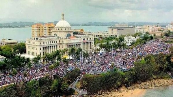
1.Puerto Rico
 |
| Photo Puerto Rico Report |
Total area: 3,424 square miles (8,868 square km)
Population: 2,829,148
Capital: San Juan
Largest city/town: San Juan
Puerto Rico is the most populous US territory, consisting of more than 2.8 million people. It is an island in the Caribbean Sea, located just east of the Dominican Republic. Puerto Rico was a Spanish colony, but during the Spanish-American War of 1898, the US seized the island, and it has been under US jurisdiction ever since. The territory has a government that resembles that of a US state, with a governor acting as the executive and a bicameral legislature, consisting of a Senate and a House of Representatives. The people of Puerto Rico are very diverse, owing to a history of conquest and the effects of the slave trade. The vast majority of Puerto Ricans adhere to Roman Catholicism, and Spanish and English are both official languages in the territory. During the US elections of 2020, Puerto Rico held a referendum on whether the island should become the 51st state. A slim majority of Puerto Ricans voted in favor of statehood, but it will be up to the US Congress to determine if the territory does, in fact, become a state.
| Legal Status Of US Territory Residents Residents of all but one of the permanently-inhabited US territories are American citizens. People in American Samoa are just considered American nationals, not citizens, meaning that they are free to travel within all of US territory, but do not have the rights and privileges that the US Constitution bestows on American citizens. In addition, US citizens in the territories do not vote in Presidential Elections. Their representation in the US Congress is also extremely limited. Residents of Puerto Rico, Guam, and the US Virgin Islands elect representatives that sit in the US House of Representatives, but they have few to no voting rights in the chamber. Residents of the territories who move to one of the 50 states, however, can fully participate in US elections. For example, there is a sizeable Puerto Rican community in certain parts of the US mainland. |
2.Guam
Total area: 217 square miles (561 square km)
Population: 169,387
Capital: Hagåtña
Largest city/town: Dededo
Guam is an island in the northern Pacific Ocean, home to more than 168,700 people. The largest ethnic group on the island is its native inhabitants, the Chamorro. There is also a large population of Filipino descent. Most of the island’s other residents are of mixed ethnic ancestry. Like Puerto Rico, Guam was also a Spanish possession until it was ceded to the US after the 1898 Spanish-American war. After World War II, Guam became an important military installation. Aside from military activity, tourism is the territory’s main industry. Guam also has the distinction of being the very first US territory to legalize same-sex marriage, following a court ruling in 2015.
| Incorporated/Unincorporated Territories, Organized/Unorganized Territories The territories are defined as either incorporated or unincorporated. Actually, only one territory, Palmyra Atoll, is considered an incorporated territory, which means that the US Constitution fully applies in the territory. The other territories are all unincorporated, which means that only select parts of the Constitution apply to them. For example, unincorporated territories do not have the right to full representation in the US Congress. The territories are also distinguished by whether they are organized or unorganized. All territories with permanent populations with the exception of American Samoa are organized, meaning that the US government has given these territories their own governments with limited autonomy. All US Territories without permanent populations are considered unorganized. |
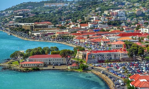
3. US Virgin Islands
 |
| Photo TripAdvisor |
Total area: 135 square miles (350 square km)
Population: 104,361
Capital: Charlotte Amalie
Largest city/town: St Croix
The US Virgin Islands is another of America’s territories in the Caribbean, which they purchased the islands from Denmark in 1917. To the east of the US Virgin Islands are the British Virgin Islands and Puerto Rico lies about 40 miles (64 km) to the west. The main islands of this US territory are St. Croix, St. John, and St. Thomas. There are also about 50 islets and cays that are considered to be part of the US Virgin Islands. Three-quarters of the islands’ inhabitants are Black, and about a tenth are white. English is the territory’s official language, though there are some residents who speak French or Spanish. Tourism and other services are the mainstays of the economy in the US Virgin Islands.
4. Northern Mariana Islands
Map showing the location of the Northern Mariana Islands in the Pacific Ocean.
Total area: 176.5 square miles (457.1 square km)
Population: 57,701
Capital: Saipan
Largest city/town: Saipan
Just north of Guam lies another US territory in the Pacific Ocean, the Northern Mariana Islands. The territory consists of 22 islands and islets, and is a self-governing commonwealth. The only other such territory in association with the US is Puerto Rico. These islands are home to more than 57,500 people, many of them Indigenous inhabitants of Micronesian heritage. Like other US island territories, tourism is the principal driver of the economy in the Northern Mariana Islands.
5.American Samoa
Total area: 77 square miles (200 square km)
Population: 55,140
Capital: Pago Pago
Largest city/town: Pago Pago
American Samoa is a US territory in a remote part of the South Pacific known as Polynesia. The territory consists of six islands and is bordered immediately to the west by the independent country of Samoa. Unlike other US territories with permanent populations, American Samoa is an unorganized territory, meaning that the US Congress has never passed an organic act formally establishing an autonomous government therein. In 1951, the US Department of the Interior was given authority to administer American Samoa, and in 1967 the territory was allowed to write its own constitution. Therefore, in practice, the territory does have some degree of self-governance. The vast majority of the population in American Samoa, numbering just over 55,000, is of native Samoan ancestry. They are US nationals so they may enter and reside in the country, but they do not have citizenship.
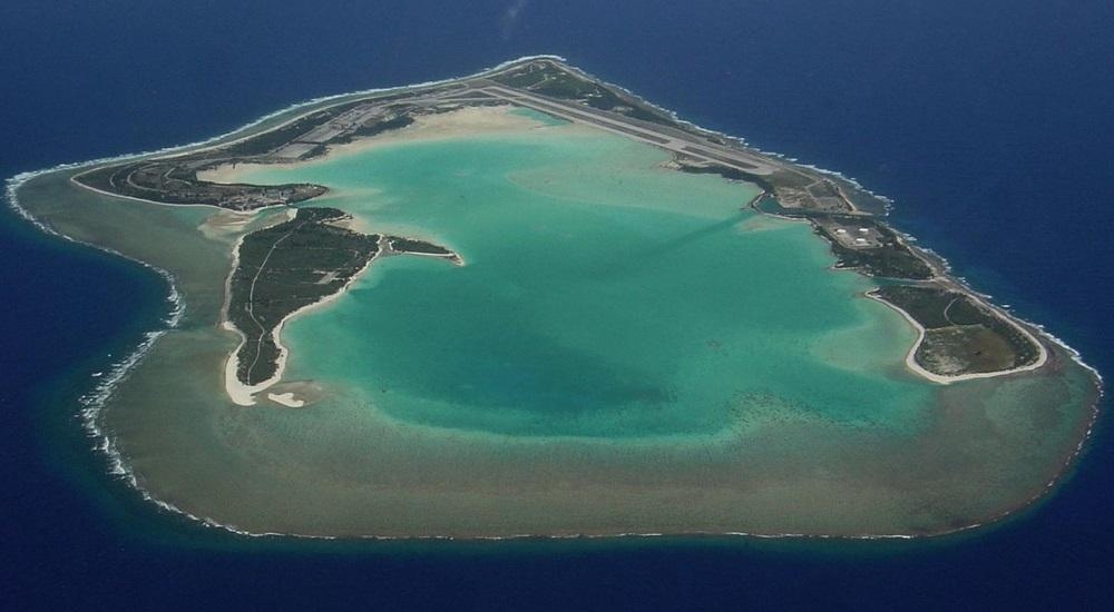
6. Midway Atoll
 |
| Photo LA Times |
Total area: 2.4 square miles (6.2 square km)
Population: 40
Midway Atoll lies in the central Pacific Ocean, 1,300 miles (2,100 km) northwest of the Hawaiian state capital, Honolulu. If the name Midway sounds familiar to you, it may be because it is also the name of an important battle in World War II, the Battle of Midway, which took place from June 3rd to 6th, northwest of the territory. Historians credit the American victory over Japanese forces in this battle as the turning point for the war in the Pacific. Today, Midway Atoll is a protected wildlife refuge. There is a very small population on the atoll, but no Indigenous inhabitants.
7. Palmyra Atoll
Total area: 4.6 square miles (11.9 square km)
Population: 20 (no permanent inhabitants)
The Palmyra Atoll is part of the volcanic island chain known as the Northern Line Islands and is located about 1,000 miles southwest of Honolulu. The atoll is named after the first American ship to make landfall there in 1802. Once a producer of copra and home to US airstrips during WWII, Palmyra Atoll is now a US National Wildlife Refuge and is also part of the Pacific Remote Islands Marine National Monument.
8. Baker Island
Total area: 0.6 square miles (1.5 square km)
Baker Island is an atoll located in the South Pacific. It was claimed by the US in 1857 and has been under US sovereignty ever since. During WWII, an airbase was built on the atoll. Today, Baker Island is a US National Wildlife Refuge, and is home to endangered sea turtles. Scientists will sometimes stay on the atoll temporarily, but otherwise there are no permanent inhabitants.
9. Howland Island
Total area: 0.6 square miles (1.6 square km)
Howland Island, like Baker Island, was claimed by the US in 1857. The two islands are actually in relatively close proximity to each other, and both were once the home of guano deposits, but these were exhausted in the 19th century. Howland Island once served as a stopover for planes traveling between Hawaii and Australia, and it is near here that Amelia Earheart disappeared in her attempted flight around the world. Today, just like Palmyra Atoll and Baker Island, Howland Island is a US National Wildlife Refuge and part of the Pacific Remote Islands Marine National Monument.
10. Jarvis Island
Total area: 1.6 square miles (4.1 square km)
Jarvis Island is located in the South Pacific, just southwest of the small country known as Kiribati. Like Palmyra Atoll, Baker Island, and Howland Island, Jarvis Island was formerly exploited for its guano deposits. The island is home to a submarine terrace, which extends to 1 km (0.62 miles) offshore. It is also a US National Wildlife Refuge and part of the Pacific Remote Islands Marine National Monument.
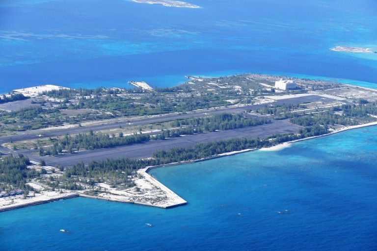
11. Johnston Atoll
 |
| Photo Pinterest |
The Johnston Atoll is the closest of the US-controlled atolls in the Pacific to the main Hawaiian Islands, about 825 miles (1,330 km) southwest of Honolulu. Some of Johnston Atoll is actually man-made. In fact, two out of four of the island's reefs were artificially created by dredging.
12.Kingman Reef
Total area: 0.01 square miles (0.03 square km)
Kingman Reef is located to the northwest of the aforementioned nation of Kiribati, relatively close to Jarvis Island. The island was formally annexed by the U.S. in 1922, and made into a naval reservation 12 years later. It remained a naval reserve until the year 2000, when it was transferred to the US Fish and Wildlife Service. One year later, the island was made a U.S. National Wildlife Refuge.
13. Wake Island
Total area: 2.5 square miles (6.5 square km)
Wake Island is located in the central Pacific Ocean, about 2,300 miles west of Honolulu. The territory is made up of three coral islets that surround a lagoon, which is also the crater of a volcano. The US claimed the territory in 1899 and in 1934, Wake Island was put under the jurisdiction of the US Navy. In 1941, Japanese Imperial forces attacked and occupied Wake Island, but it was returned to U.S. control after Japan surrendered at the end of WWII.
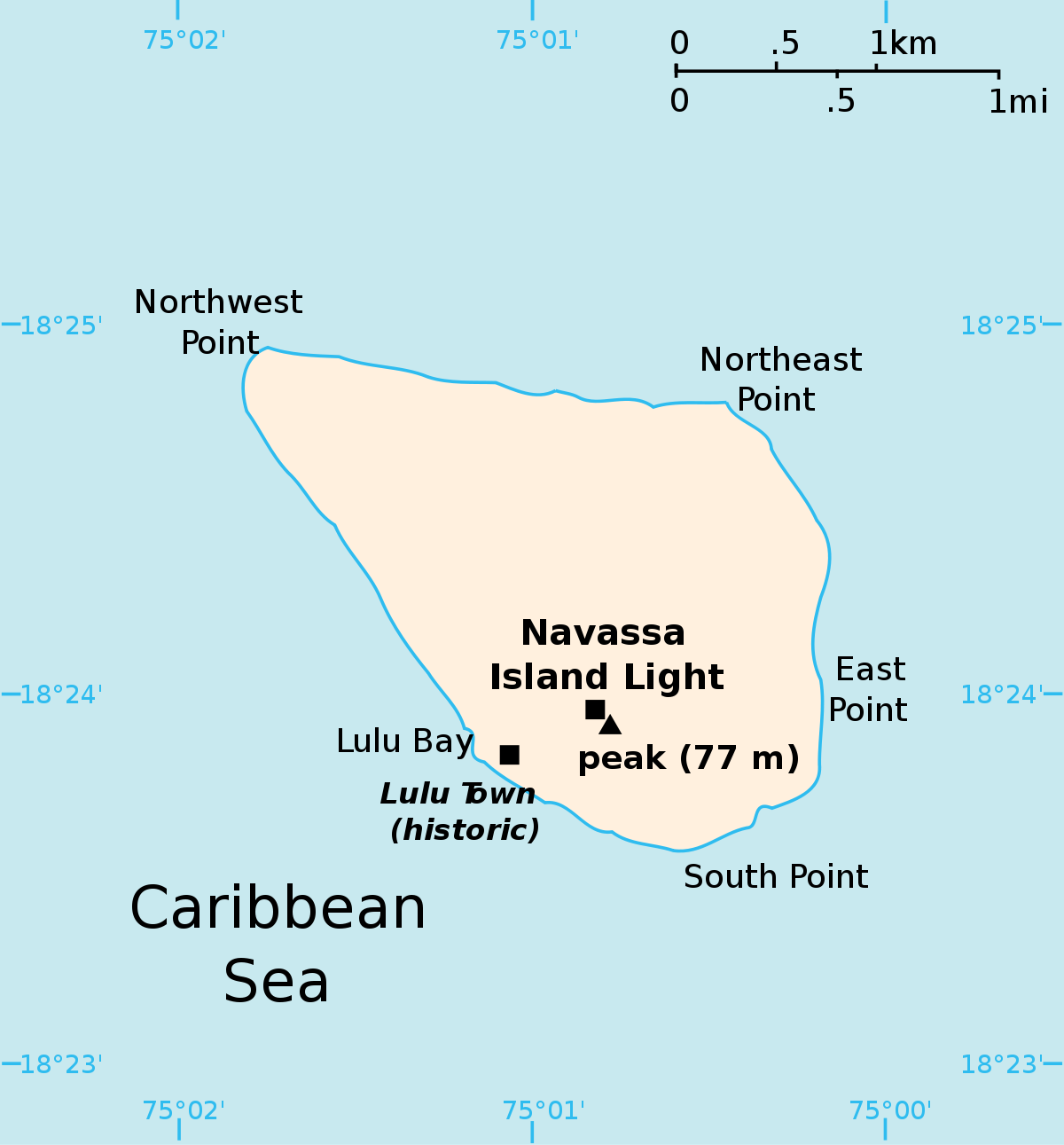
14. Navassa Island
 |
| Photo Wiki |
Total area: 2.1 square miles (5.4 square km)
Navassa Island is a Caribbean island located close to the west coast of Haiti. The US took control of the island in 1857 and exploited phosphate there until the end of the century. In 1999, Navassa Island was made into a wildlife refuge.
15. Bajo Nuevo Bank
This small uninhabited reef in the western Caribbean Sea was first shown on Dutch maps dating back to 1634. After very little recognition it was rediscovered by English pirate John Glover in 1660. The reef is administered by Colombia, but a number of other states —Jamaica, Nicaragua and the US—claim sovereignty over it.
On the 19th November 2012, with regards to the Nicaraguan claim the International Court of Justice ruled unanimously, that the Republic of Colombia has sovereignty over both the Bajo Nuevo and the Serranilla bank of the reef. The U.S. administers the bank as an unorganized, unincorporated United States territory.
16. Serranilla Bank
Serranilla Bank (Spanish: Isla Serranilla, Banco Serranilla and Placer de la Serranilla) is a partially submerged reef, with small uninhabited islets, in the western Caribbean Sea. It is situated about 350 kilometres (220 mi) northeast of Punta Gorda, Nicaragua, and roughly 280 kilometres (170 mi) southwest of Jamaica. The closest neighbouring land feature is Bajo Nuevo Bank, located 110 kilometres (68 mi) to the east.
Serranilla Bank was first shown on Spanish maps in 1510. It is administered by Colombia as part of the department of San Andrés and Providencia. The reef is subject to a sovereignty dispute involving Colombia, Honduras and the United States. In 2012, in regards to Nicaraguan claims to the islands, the International Court of Justice (ICJ) upheld Colombia's sovereignty over the bank.
 What are the Caribbean Countries? What are the Caribbean Countries? Do you know how many countries are there in Caribbean? And what are they? Keep reading the article below to find out. |
 How Many Countries Are There In Oceania? How Many Countries Are There In Oceania? Do you know how many countries the Oceania has? What are the names of the countries? |
 Facts About Landlocked Countries in The World Facts About Landlocked Countries in The World Landlocked countries have some very unique issues that they have to deal with. In this article, we're going to explore the definition of landlocked countries ... |


