The Automated Surface Observing Systems (ASOS): Components, Measure, Role in Weather Forecasting
 |
| The Automated Surface Observing Systems (ASOS) |
What is the Automated Surface Observing System ASOS?
The daily high temperature reported by your local TV weathercaster likely originates from an Automated Surface Observing System (ASOS) at your nearby airport.
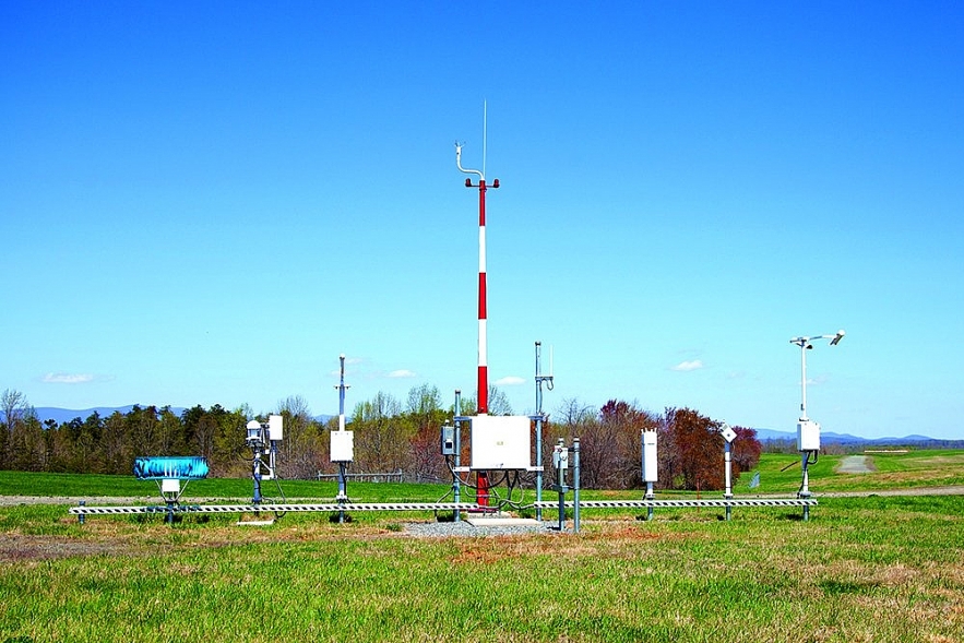
An Automated Surface Observing System comprises a collection of meteorological sensors that measure, gather, and distribute weather data.
This assists meteorologists, pilots, and flight dispatchers in preparing and monitoring weather forecasts, planning flight routes, and supplying essential information for accurate takeoffs and landings.
ASOS is a federally funded joint initiative involving the National Weather Service, the Federal Aviation Administration, and the Department of Defense. ASOS has been operational since the early 1990s and is situated at over 900 locations nationwide.
These sites offer continuous monitoring and are essential for the safety of pilots, aircraft, and passengers. Given that safety is the primary concern in air travel, the majority of Automated Surface Observing Systems (ASOSs) are situated at airports to guarantee the most precise conditions are communicated to the National Weather Service and air traffic controllers. The continuous data streams from ASOS sites offer essential insights for precise forecasting, serving as a significant climatological instrument.
One notable distinction is the variation in wind observations. AWOS transmits true wind direction, whereas ASOS translates surface winds into magnetic direction. The identification of precipitation types and the reporting of thunderstorms differ between the two.
| The ASOS program is a federally funded collaborative initiative involving the National Weather Service (NWS), the Federal Aviation Administration (FAA), and the Department of Defense (DOD). The systems function as the principal surface weather observation network in the United States, providing valuable data when tropical cyclones approach the coast, make landfall, or progress inland. |
What Role Does the ASOS Play in Weather Forecasting?
ASOS has greatly enhanced the data accessible to meteorologists and the aviation sector with its extensive and contemporary array of weather sensors. The ASOS network has more than doubled its full-time surface weather observation sites. ASOS operates continuously, refreshing data every minute, 24 hours a day, throughout the entire year.
Acquiring additional atmospheric data more frequently and from diverse locations is essential for enhancing forecasts and alerts. Consequently, ASOS data will assist the NWS in enhancing the precision and promptness of its forecasts and alerts, which is the primary objective of NWS modernization.
The foremost concern of the aviation sector is safety, which is frequently jeopardized by weather conditions. A fundamental advantage of ASOS is that essential aviation weather parameters are assessed precisely in the airport runway touchdown zones.
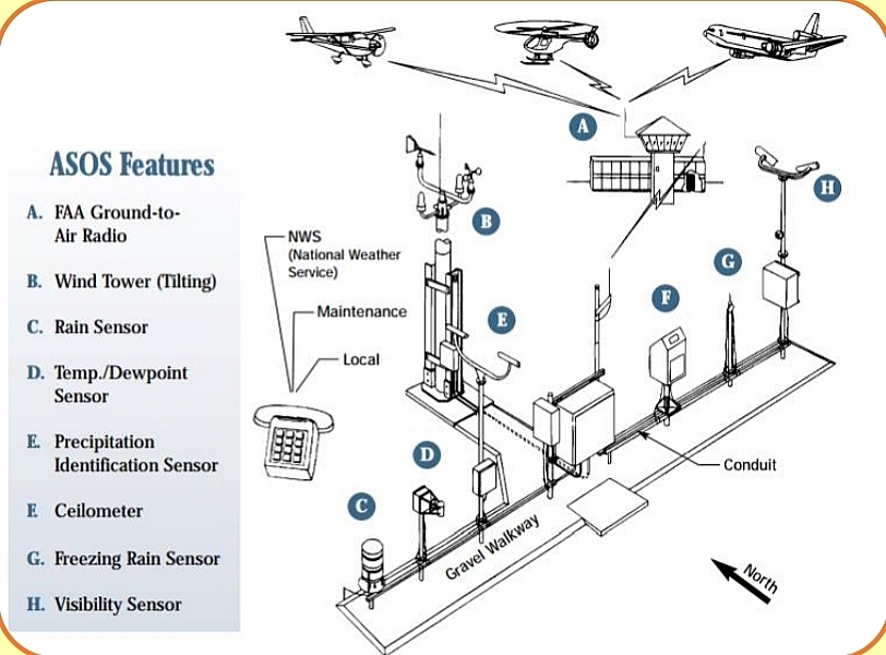
ASOS identifies substantial variations, transmitting hourly and special reports through the networks. Moreover, ASOS consistently and autonomously transmits computer-generated voice reports directly to aircraft near airports via FAA ground-to-air radio. These messages are also accessible through a telephone dial-in port. ASOS autonomously observes, formats, archives, and transmits data. ASOS issues a special report when specific weather element thresholds are surpassed, such as when visibility falls below 3 miles.
How Does ASOS Measure Visibility?
ASOS-monitored weather conditions include:
An ASOS station is a terrestrial array of instruments and electronic sensors utilized to autonomously generate and process surface observations and atmospheric measurements in near real-time. The systems offer observations at 1-minute, 5-minute, hourly, and special intervals continuously, 24 hours a day. A dataset is gathered over time to yield a "representative" observation, after which the system employs mathematical logic, known as algorithms, to extrapolate weather conditions across a broader region.
temperaturehumidity
pressure
wind speed
wind direction
precipitation amount
precipitation type
Currently, automated weather stations cannot report a range of meteorological conditions. ASOS equipment is constrained in its capability to detect only the weather directly overhead; consequently, weather that has not interacted with the sensors remains unmeasured. Certain meteorological conditions
ASOS equipment is incapable of measuring the following:
shallow or patchy fog
tornadoes
precipitation that is not in the form of rain or snow, such as hail and ice pellets
multiple forms of precipitation falling at the same time
in-cloud and cloud-to-cloud lightning
clouds that are not directly above the station
clouds that are more than 12,000 ft above ground level
cloud type
Research is ongoing to enable automated stations to detect various weather conditions. All these conditions are pertinent to the meteorological community, as many can pose hazards to aircraft. Consequently, most busy airports employ part-time or full-time human observers to supplement the data from automated weather stations. ASOS equipment may experience mechanical failure, necessitating repair or replacement. During system outages, human observers are frequently necessitated to augment absent or unrepresentative observations. Researchers are endeavoring to develop more resilient systems that are less susceptible to environmental damage, mechanical degradation, and icing.
Equipped with the most advanced and extensive weather sensors, ASOS machines have greatly enhanced the data accessible to meteorologists, particularly concerning nocturnal observations. The ASOS program has more than doubled the quantity of full-time surface weather observation sites. Acquiring additional atmospheric data more frequently and from diverse locations is essential for enhancing the accuracy of forecasts and warnings issued by the NWS.
The ASOS - Main Components
1. A sensor group, consisting of individual weather sensors and a Data Collection Package (DCP). The DCP continuously gathers and processes the raw data from the sensors and prepares it to be transferred to the ACU. This component is found at every ASOS site.
2. The Acquisition Control Unit (ACU), which is the Central Processing Unit for the ASOS site. It performs the final processing, formatting, quality control, and storage of the data, and makes it available to its users. The ACU is located inside a temperature controlled room near the sensor groups. This component is found at every ASOS site.
3. The Operator Interface Device (OID), which allows an observer to enter backup or augmented observations directly into the ACU. This component is found only at airports that offer backup support.
The ASOS Sensor Group is Composed of the Following
• Wind Speed & Direction - A wind vane (for wind direction) and rotating anemometer cups (for wind speed). Wind gusts are measured by looking for winds that are stronger than the current wind and are sustained over a period of time.
• Altimeter (Barometric pressure) - Two or three pressure transducers measure barometric pressure. The transducers must be within a certain range of each other for the pressure to be reported. The barometers are located in the bottom tray of the ACU.
• Relative Humidity/Dew Point - A hygrothermometer is used to measure dewpoint. The process involves using a fan to draw ambient air into the housing and over a mirror that has been electronically cooled to a lower temperature. The cooling process continues until the dewpoint temperature is reached, at which time a layer of dew forms on the mirror. A laser beam and detector are used to detect dew formation. At that time, the mirror temperature is read and recorded as the dewpoint temperature.
• Air Temperature - This measurement is made by a thermistor, a type of electronic thermometer. Readings are generally very accurate. It is located in the same place.
• Precipitation Type & Amount- This is determined by a light-emitting-diode weather identifier, or LEDWI. This device measures the passage of particles through a sensor beam. Much of this instrument’s logic is tied into calculations, relating to fall velocity patterns. Snow falls slowly and makes one type of pattern, while rain falls at a faster rate, creating another signature. The LEDWI was designed only to report the occurrence of rain or snow at precipitation fall rates of .01 inch per hour or greater.
• Visibility- This is determined by a scatter meter, which is a device that measures the amount of radiation scattered from a beam of light by particles in the air such as fog, rain, snow, or other airborne particulates. This yields a measurement of air clarity. The measurement is processed through algorithms designed to correlate the readings with familiar visibility values.
• Cloud Height & Density- A laser beam ceilometer is used to measure cloud height, vertical visibility, and sky cover. A laser beam is pointed directly up in the sky; when clouds are overhead it reflects back to the sensor and is converted into a height measurement.
• Lightning Detection- This sensor can detect cloud to ground and cloud to cloud lightning strikes. All strikes are counted, but only cloud to ground strikes are used to estimate the distance from the sensor. The strikes are then placed into either the 0 to 5 mile category, 5 to 10 mile category, or the 10 to 30 mile category.
Putting the Parts Together
 |
| ASOS sensors |
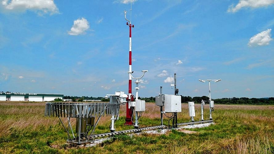
Now that each part of the ASOS has been introduced, the full picture of the sensor suite can be seen below in Figure 8. The sensors relay the raw data to the DCP, which then transmits it to the ACU where the data is processed and formatted to be sent out.
| Although not an impeccable mimic of humans, ASOS serves as a valuable instrument for both meteorologists and aviators. ASOS's continuous monitoring facilitates 24/7 information to enhance air travel safety. Forecasters and aviation personnel must acknowledge that despite ASOS's numerous advantages, it captures only a segment of the prevailing atmosphere, necessitating the utilization of additional sources to ascertain a comprehensive understanding of atmospheric conditions. |
What is the Difference Between ASOS, AWOS and ATIS?
 |
| Difference Between ATIS, AWOS, and ASOS |
Realtime weather reporting for aviation is a vital tool for pilot decision making and planning. Pilots have three primary types of real time or near real time weather reports available to them: ATIS, AWOS and ASOS.
AWOS and ASOS are automated and provide continuous real-time weather observations.
ATIS contains current, routine information to arriving and departing aircraft as well as weather reports derived from human data collection that is updated hourly or upon pertinent data changes.
An ASOS (Automated Surface Observing System) station is functionally similar to AWOS (Automated Weather Observation System) stations but is managed, maintained and controlled by NOAA rather than the FAA or the organization that operates the airport.
ASOS stations may be found in locations other than airports if they serve to improve weather awareness in locations pertinent to general public.
These systems may or may not be monitored and include the “AUTO” tag in the textual output if no human observer is present.
An AWOS (Automated Weather Observation System) station is a weather station that collects and broadcasts weather on a minute-by-minute basis.
These systems are largely automated but may include human observer monitoring when visibilities are reduced; if the AWOS is unmonitored, an “AUTO” tag is included in the textual output.
AWOS systems meet a variety of standards, however most systems include altimeter setting, winds, temperature and dewpoint, density altitude, visibilities, and ceilings.
The ATIS (Automatic Terminal Information Service) weather product is often the easiest to identify and remember where it is found. ATIS reports are generated hourly (or as required) by human recording of weather conditions, meaning an operating control tower is required to receive this type of real time weather data.ATIS will be found at Class B, C and some Class D airports.
An ATIS report includes the airport, report identifier, time, runway in use, winds, visibility, cloud data, temperature and dewpoint, altimeter setting and then any additional pertinent information.
FAQ
What role does the Automated Surface Observing Systems ASOS play in weather forecasting?
What function does the Automated Surface Observing Systems (ASOS) serve in meteorological forecasting? It serves as the nation's principal meteorological observation network. What tool improves weather forecasts by facilitating monitoring, essential for predicting global weather and environmental phenomena?
What role does ASOS play in weather forecasting?
What function does the Automated Surface Observing Systems (ASOS) serve in meteorological forecasting? It is a radar sensor system employed for storm tracking. It serves as the nation's principal meteorological observation network. It delivers meteorological reports similar to those of the National Weather Service.
What role does the Automated Surface observing System ASOS?
In-cloud and cloud-to-cloud lightning. clouds located away from the station's vertical position. clouds exceeding 12,000 feet above ground level. Type of cloud.
What is ASOS meteorology?
The Automated Surface Observing System (ASOS) program is a collaborative initiative involving the National Weather Service (NWS), the Federal Aviation Administration (FAA), and the Department of Defense (DOD). The ASOS system functions as the country's principal surface weather observation network.
What is an ASOS system?
These automated systems continuously gather observations, operating 24 hours a day. ASOS data are stored in the Global Surface Hourly database. The Federal Aviation Administration operates and controls Automated Weather Observing System (AWOS) units.
What role does the Automated Surface Observing Systems (ASOS) play in weather forecasting?
It is the nation’s primary weather-observing network. Which tool enhances weather forecasts by enabling monitoring, which is necessary for predicting global weather and environmental events?
What is the Automated Surface observing Systems?
Automated Surface Observing System (ASOS) units are automated sensors that deliver localized weather information to an air charter operator prior to and during their flight. In the United States, there are over 900 ASOS units located at various airports and other sites.
What do weather maps display weather stations?
A weather map illustrates meteorological information pertaining to a particular location at a specific moment. It can display temperature, cloud cover, precipitation (rain or snow), wind, atmospheric pressure, humidity, and the trajectory of a weather system or its anticipated movement.
What are the common components that make up the Automated Surface observing System ASOS and the Automated weather observing System AWOS)?
Automated Surface Observing System (ASOS)* These systems generate weather observations containing the following:
- Wind speed, direction, and gust information.
- Temperature.
- Dew point.
- Altimeter setting.
- Cloud height and amount.
- Visibility.
- Present weather.
- Precipitation accumulation.
What ASOS stands for?
ASOS is an acronym for As Seen On Screen, with its original tagline stating, 'Purchase what you observe in film and television.' ASOS initially launched over twenty years ago as a clothing website associated with celebrities.
What type of rain gauge is used in automated surface observation stations ASOS )?
The initial device for measuring precipitation accumulation in automated airport weather stations was the heated tipping bucket rain gauge. The upper section of this apparatus features a collector with a diameter of 1 foot (0.30 m) and an open top.
Why would you place an ASOS system in an open field?
The ASOS data has potential applications that extend beyond basic aviation weather information and forecasting; it will also offer significant support to essential national programs including public safety, hydrology, climatology, agriculture, and environmental protection, among others.
How are computers used in producing weather forecasts?
In what ways are computers utilized in the generation of weather forecasts? They aggregate data from various instruments. They gather data on air temperature and air pressure. They obviate the necessity for human meteorologists.
How does ASOS measure visibility?
The ASOS system employs a laser ceilometer to analyze cloud strata in the atmosphere. The system records measurements every 30 seconds for a duration of 30 minutes, subsequently double-weighing the data during the final 10 minutes to enable the computer to determine whether the cloud layers are scattered, broken, or overcast.
When was the Automated Surface Observing Systems invented?
The Automated Surface Observing System (ASOS) program was a joint effort between the Federal Aviation Administration (FAA) and the National Weather Service (NWS) to deploy a network of high-grade weather monitoring stations across the United States. In 1991, Systems Management Inc. (now All Weather Inc.)
What are radiosondes used for?
Radiosondes quantify atmospheric pressure, air temperature, humidity, and wind characteristics (speed and direction). Contemporary radiosondes incorporate a GPS receiver to ascertain wind velocity and orientation, along with a radio transmitter to relay the data to the surface.
 Top 10 Beautiful Young Weather Girls on U.K TV Top 10 Beautiful Young Weather Girls on U.K TV Find out the top 10 most beautiful TV weather girls (TV weather presenters) under 40 in the UK 2023/2024. |
 Top 10 Most Beautiful Weather Girls in the U.S And South America Top 10 Most Beautiful Weather Girls in the U.S And South America Our weather forecast channel's weather girls (presenters) are just as beautiful as our master of ceremonies (MC) during breaking news segments. |
 Top 10 Most Beautiful Female Weather Reporters In The World Today Top 10 Most Beautiful Female Weather Reporters In The World Today There are many gorgeous ladies on television, particularly those who cover the weather. These remarkable ladies have contributed significantly to the advancement of the media ... |
 Top 10 Free Websites and Apps to Forecast Germany Weather Top 10 Free Websites and Apps to Forecast Germany Weather KnowInsiders extensively reviews various websites and applications to curate a list of the top 10 English-language weather forecast resources for tourists visiting Germany. This facilitates ... |


